Please see attachment.
Chapter 13: Strategic Development Regeneration Areas (SDRAs)
Dúnta27 Iúil, 2022, 9:00am - 1 M.F., 2022, 4:30pm
Material Alteration Reference Number 13.1 |
All SDRA maps are amended as follows:
(“Permeability Interventions” and “Greening, Cycle and Pedestrian Corridors”)
{“Access and Permeability Corridor”}
Relevant Maps/Figures are shown are shown sequentially below. The symbols on the key are amended accordingly.
Material Alteration Reference Number 13.2 |
Chapter 13
Section: Section 13.1 Introduction
Page: 466, 2nd paragraph
Amendment:
The active land management measures and approach referred to under the core strategy will be pursued in the development and delivery of the SDRAs. {Table 13.1 sets out the 17 SDRA’s, their estimated capacity and key supporting infrastructure.}
Delete Table 13.1 and replace with following table:
{Table 13.1: Capacity of SDRA Designated Lands for Residential Use or a Mixture of Residential and Other Uses and Supporting Infrastructure}
|
SDRA Ref. |
City Area Name |
Estimated Capacity |
Area (Ha) |
Supporting Infrastructure |
|
SDRA 1 |
Clongriffin/Belmayne and Environs |
6,950 – 7,350 |
52 |
DART+, Bus Connects, completion of Main Street, social infrastructure |
|
SDRA 2 |
Ballymun |
2,200 – 2,350 |
35 |
Metrolink, Bus Connects |
|
SDRA 3 |
Finglas Village Environs and Jamestown Lands |
2,800 |
52 |
Luas Finglas, Bus Connects, social infrastructure |
|
SDRA 4 |
Park West/Cherry Orchard |
2,500 – 3,100 |
49 |
DART+, Bus Connects, social infrastructure. |
|
SDRA 5 |
Naas Road |
3,300 |
18 |
Bus Connects, Luas stop, Water service upgrade |
|
SDRA 6 |
Docklands |
7,900 |
24 |
DART+, Dodder Bridge, Bus Connects, Luas Poolbeg, District Heating, social infrastructure |
|
SDRA 7 |
Heuston and Environs |
1,250 |
14 |
DART+, Bus Connects |
|
SDRA 8 |
Grangegorman/Broadstone |
900 |
11 |
Bus Connects |
|
SDRA 9 |
Emmet Road |
1.050 |
15 |
Bus Connects, social infrastructure |
|
SDRA 10 |
North East Inner City |
850 |
12 |
DART+, Bus Connects, social infrastructure |
|
SDRA 11 |
St. Teresa’s Gardens |
950 |
13 |
Bus Connects |
|
SDRA 12 |
Dolphin House |
350 |
6 |
Bus Connects |
|
SDRA 13 |
Markets Area and Environs |
400 |
8 |
Public realm |
|
SDRA 14 |
St. James’ Medical Campus and Environs |
- |
- |
Bus Connects |
|
SDRA 15 |
Liberties and Newmarket Square |
2,500 |
30 |
Bus Connects, social infrastructure, public realm |
|
SDRA 16 |
Oscar Traynor Road |
850 |
17 |
Bus Connects |
|
SDRA 17 |
Werburgh Street |
100 |
2 |
Public realm |
|
|
Total |
34,750 – 35,950 |
358} |
|
Material Alteration Reference Number 13.3 |
Chapter 13
Section: 13.1 Introduction
Page: 467, 2nd paragraph
Amendment:
The guiding principles plans are not intended to be prescriptive, but seek to set out an overall strategy for each site in terms of the appropriate form and scale of development, key routes and permeability, open space etc. (Minor deviations from the guiding principles map may be acceptable) {Some flexibility in the interpretation of the guiding principles maps will be applied} where the applicant can demonstrate that the overall intent of the guiding principles has been incorporated and considered and that an appropriate development response for the site has been developed.
Material Alteration Reference Number 13.4 |
Chapter 13
Section: After section 13.1
Page: 467
Amendment:
The following text will be added to Chapter 13 after section 13.1 as a new section, subsequent section titles to be renumbered accordingly
{13.2 Alignment of Strategic Development and Regeneration Areas with the NPF and RSES
As set out in Chapter 1, the Development Plan is informed by a hierarchy of international, national and regional policies. Of particular note, is the National Planning Framework (2018) and the Regional Spatial and Economic Strategy (2019-2031). Chapter 2, the Core Strategy, details how the policies and objectives of these documents will influence the future growth and development of the city. Table 2.8 in Chapter 2 –clearly shows the alignment of the SDRAs with the core strategy and sets out information regarding the area, population and yield of each area.
In terms of the NPF, the SDRA’s will play a key role in meeting the National Strategic Objectives, and particularly those of compact growth (NSO 1), sustainable mobility (NSO 4), and the transition to a low carbon and climate resilient society (NSO 8). In accordance with National Policy Objective 3b, the SDRA’s are critical to the delivery of the core strategy and compliance with the objective that 50% of new homes are within the existing built up footprint of the city.
The designated SDRA’s align with the overarching objectives of the NPF and RSES. They will be drivers of economic growth and investment in the city in line with NPO 5. Their development is also important in the context of NPO 6, and the vision of the plan is that the SDRA’s will be developed over the plan period for significant residential and employment uses developed in tandem with high quality social and community infrastructure and amenities, served by excellent public transport.
More specifically the ongoing development of the National Children’s Hospital (SDRA 14) and Grangegorman campus (SDRA 8) align with NSO10. The development of Clongriffin (SDRA 1); the development of ambitious largescale regeneration areas; and facilitating the growth and expansion of Dublin Port (SDRA 6) will play a key role in supporting the strategic growth enablers for Dublin City as identified in the NPF.
In terms of the RSES, a number of Residential Strategic Development Areas (SDA’s) are identified. Many of the SDRA’s identified align with these SDA’s and will provide for high quality, higher density residential development in line with RPO 5.4. The RSES also identifies a number of Employment Strategic Development Areas which also align with the SDRA’s. The development of these areas will accord with objective RPO 5.6 of the RSES (see also section 1.9.6, Chapter 1). It is envisaged that the relevant SDRA’s will be developed for appropriate employment densities in tandem with the provision of high quality public transport corridors.}
Material Alteration Reference Number 13.5 |
Chapter 13
Section: 13.2 Overarching Principles
Page: 467 – 469, insert New Objective SDRAO1 in section 13.2 after 1st paragraph
Amendment:
After 1st paragraph delete existing text in section 13.2 and replace with the following text:
{13.2.1 Overarching Principles and Vision
Objective SDRAO1 Overarching Principles and Vision
It is the objective of Dublin City Council:
To support the ongoing redevelopment and regeneration of the SDRA’s in accordance with the guiding principles and associated map; the qualitative and quantitative development management standards set out in Chapter 15; and in line with the following overarching principles:
Architectural Design and Urban Design: All development within the SDRAs must be of the highest architectural quality and adhere to the key architectural and urban design principles set out in Chapter 15 in order to create long term, viable and sustainable communities aligned with the principles of the 15-minute city.
Phasing: Large scale development proposals should be developed in accordance with agreed phasing plans to ensure that adequate social and physical infrastructure is delivered in tandem with development.
Access and Permeability: Development proposals should ensure adequate permeability and connectivity to surrounding neighbourhoods and public transport infrastructure through the provision of high quality, accessible public realm and high-quality walking and cycling infrastructure. Access and layout should accord with the principles of DMURS.
Height: Guiding principles regarding height are set out for each SDRA. Where development adjoins lower scaled residential communities, development must be appropriately designed so that no significant adverse impacts on the residential amenities of adjacent residential properties arises. The performance criteria set out in Appendix 3 should be adhered to for developments of significant scale and/or density.
Urban Greening and Biodiversity: Development proposals within the SDRA must ensure the integration of greening and biodiversity measures including high quality public open space as well as micro greening measures including green walls, green roofs, parklets etc. In general, unless otherwise specified under a separate LAP/SDZ Planning Scheme/other statutory plan policy/objective or site-specific guiding principle, a minimum of 10% public open space should be provided as part of all development proposals in SDRAs. A financial contribution in lieu of same will only be considered in exceptional circumstances.
Surface Water Management: All development proposals should provide for sustainable surface water management and the installation of sustainable drainage systems (SuDS) in order to reduce surface water runoff and potential flooding. This should be considered in conjunction with open space design and greening/biodiversity initiatives. See Appendix 11, 12 and 13 for further detail.
Flood Risk: All development proposals within the SDRA’s will have regard to restrictions / measures to mitigate identified flood risk outlined in Strategic Flood Risk Assessment and in particular, Appendices A and B.
River Restoration: Opportunities for enhanced river corridors are applicable to the following Strategic Development and Regeneration Areas (SDRAs) in order to harness significant opportunities for river restoration where feasible: SDRA 1 Clongriffin/Belmayne and Environs; SDRA 3 Finglas Village Environs and Jamestown Lands; SDRA 4 Park West/Cherry Orchard; SDRA 5 Naas Road; SDRA 6 Docklands; SDRA 7 Heuston and Environs; SDRA 9 Emmet Road; SDRA 10 North East Inner City and SDRA 16 Oscar Traynor Road. See Chapter 9, Policy SI12 for further detail.
Sustainable Energy: Climate Action Energy Statements for significant new residential and commercial developments, in Strategic Development and Regeneration Areas (SDRAs), will be required to investigate local heat sources and networks, and, where feasible, to demonstrate that the proposed development will be ‘District Heating Enabled’ in order to facilitate a connection to an available or developing district heating network. Further specific guidance regarding ‘District Heating Enabled’ Development is set out in Chapter 15 and should be complied with. Specific guidance is set out regarding SDRA 6 (Docklands) and SDRA 10 (NEIC) where applicants must demonstrate how a proposed development is District Heating Enabled and will connect to the ‘Docklands and Poolbeg’ DDHS catchment. Guidance is also set out regarding SDRA 7 (Heuston and Environs), SDRA 8 (Grangegorman/Broadstone), SDRA 11 (St. Teresa’s Garden and Environs), SDRA 14 (St. James Medical Campus & Environs), SDRA 15 (Liberties and Newmarket Square) where possible connections or interconnections to existing heat networks in the area, to create a district heating ‘node’ must be investigated.
Climate Change: Proposed developments within the SDRA shall be required to apply innovative approaches to energy efficiency, energy conservation and the use of renewable energy in order to contribute to achieving zero carbon developments.
Cultural Infrastructure: All new regeneration areas (SDRAs) and large-scale developments above 10,000 sq. m. in total area must provide at a minimum 5% community, arts and culture internal floorspace as part of their development. See policy CUO21, Chapter 12 for further detail.}
Material Alteration Reference Number 13.6 |
Chapter 13
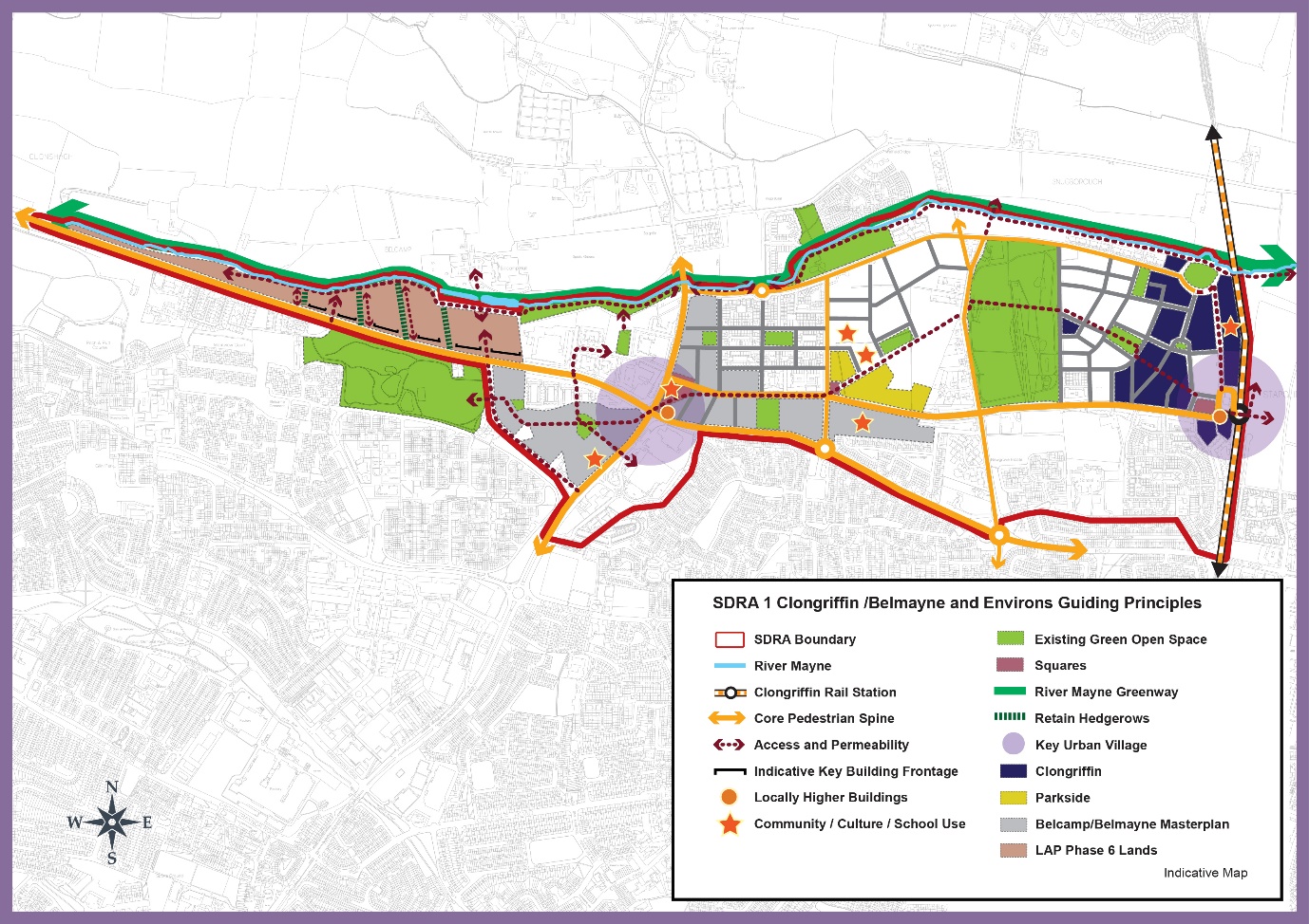
Figure 13-1: SDRA 1 Clongriffin/Belmayne and Environs
Page: 476, amendments to graphic map
Amendment to Graphic Map:
- “Permeability Intervention” leading from top left corner of the large green open space omitted and replaced with an “Access and Permeability” guiding principle.
- Two of the “Permeability Intervention” guiding principles connecting through the LAP Phase 6 lands omitted and replaced with “Access and Permeability” guiding principles.
- Removal of “Permeability Intervention” guiding principle connecting through the eastern most Clongriffin lands and replacement with an “Access and Permeability” guiding principle.
- Removal of “Permeability Intervention” guiding principle running along west side of Clongriffin lands designated for “Community/ Culture/ School Use” and replacement with an “Access and Permeability” guiding principle.
Material Alteration Reference Number 13.7 |
Chapter 13
Section: 13.4 – SDRA 2 – Ballymun, Introduction,
Page: 477, 4th Paragraph, 2nd sentence
Amendment:
The remaining sites have the capacity to deliver (c.1,700) {between 2,200 – 2,350} new housing units, new commercial and employment opportunities having regard to compact growth principles, development of infill sites and intensification of development along the proposed new Metrolink route.
Material Alteration Reference Number 13.8 |
Chapter 13
Section: 13.5 SDRA 3 - Finglas Village Environs and Jamestown Lands, subsection Jamestown Road Character Area
Page: 489
Amendment:
Note: deviations in use mix and in relation to density ranges (of up to 10%) within individual sites and quarters to meet design requirements {will be open for consideration during the Masterplan preparation process},and accepted if the change supports overall compliance with the guiding principles, and where a joint agreement is proposed between landowners to accommodate certain uses within a particular area, such will be considered where the overall principles are retained and the use and typology is delivered.
Material Alteration Reference Number 13.9 |
Chapter 13
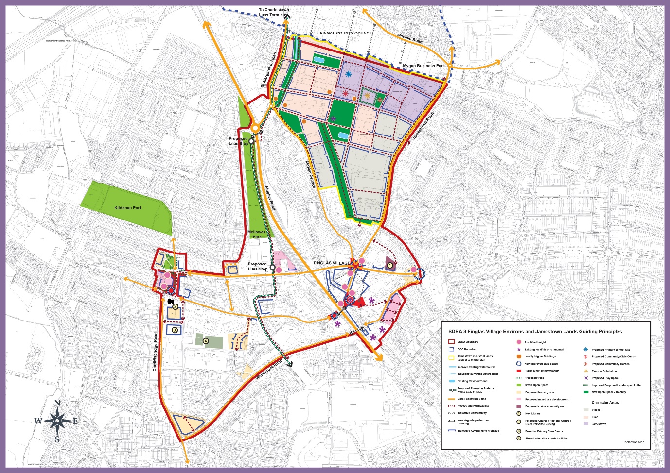
Figure 13-3: SDRA 3 Finglas Village Environs and Jamestown Lands
Page: 492, amendments to graphic map
Amendment to Graphic Map:
- Include the full extent of the sites at Iceland and Raven House.
- “Permeability Intervention” guiding principle on Cardifsbridge Road omitted and replaced by an “Access and Permeability” guiding principle.
- “Permeability Intervention” guiding principle replaced by an “Access and Permeability” guiding principle between Opportunity Sites 2 and 3 on east side of Cardiffsbridge Road.
- “Permeability Intervention” guiding principle on Proposed Housing Site to north of Wellmount Court omitted and replaced by an “Access and Permeability” guiding principle.
- “Permeability Intervention” guiding principle connected with Opportunity Site 1 omitted and replaced with an “Access and Permeability” guiding principle.
- Indicative key building frontage along Jamestown Road extended further northwards.
- Indicative key building frontage along Jamestown Road extended further northwards along Seamus Ennis Road.
- “Permeability Intervention” guiding principle within the internal road network within the Jamestown industrial lands subject to masterplan omitted and replaced with an “Access and Permeability” guiding principle.
Material Alteration Reference Number 13.10 |
Chapter 13
Section: 13.6 SDRA 4 – Park West/Cherry Orchard, subheading Introduction
Page: 494, 3rd paragraph
Amendment:
Eight key development sites are identified with the capacity to deliver in the order of 2,500 – 3,100 new residential units alongside new employment and retail opportunities, with higher densities focused on the railway station which is planned to be upgraded to an electrified DART line. The plan also supports the delivery of two key amenity sites at Cherry Orchard Park and Gallanstown Waterworks, linked via a strategic green infrastructure network.
{It should be noted that the SDRA adjoins lands part of the City Edge Project to the south. Dublin City Council together with South Dublin County Council are currently in the process of preparing “The City Edge Project” funded under the Urban Regeneration and Development Fund (URDF) programme which is a new Strategic Framework Plan for the Naas Rad, Ballymount and Park West area comprising of c. 700 hectares, and it is important that the two designated areas mutually benefit each other.}
Material Alteration Reference Number 13.11 |
Chapter 13
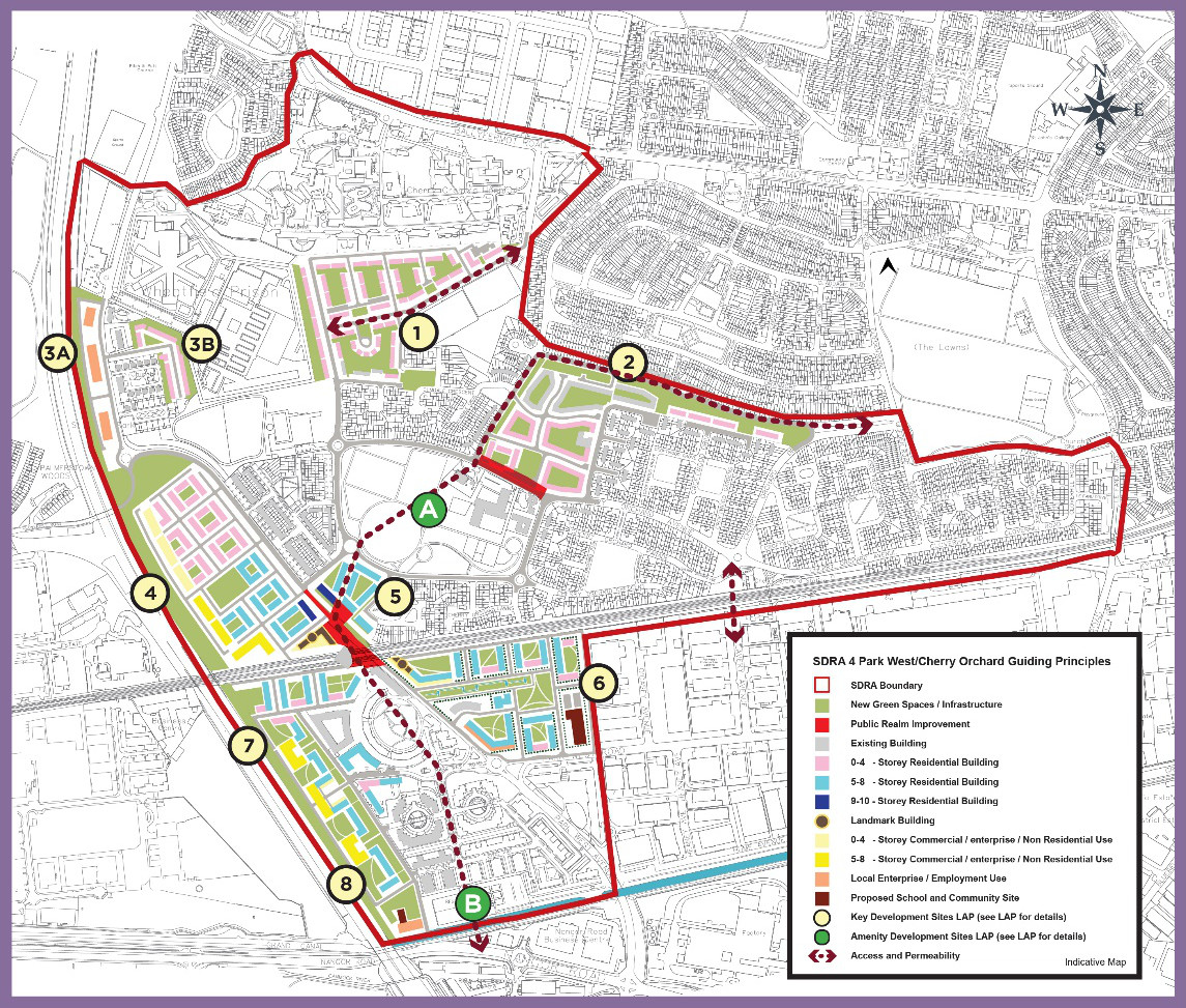
Figure 13-4: SDRA 4 Park West/Cherry Orchard
Page: 498, amendments to graphic map
Amendments to Graphic Map:
- “Permeability Intervention” guiding principle within the internal road network within LAP Key Development Site 1 omitted and replaced with an “Access and Permeability” guiding principle.
- Minor change to landmark building configurations in LAP Key Development Site 5 (to north-west and south-east of Parkwest Cherry Orchard Train Station).
- “Permeability Intervention” guiding principle between Lavery Avenue and SDRA area omitted and replaced with an “Access and Permeability” guiding principle.
Material Alteration Reference Number 13.12 |
Chapter 13
Section: 13.7 SDRA 5 – Naas Road, Introduction
Page: 499-500
Amendment:
A Local Area Plan (LAP) for the Naas Road lands was adopted by the City Council on 14 January 2013. The plan was extended for a further 5 years in 2018 and will expire in January 2023. The plan area covers approximately 100 hectares and contains a number of major brownfield sites. It occupies a strategic location on a gateway point into the city with good public transportation links to the wider metropolitan area. {Dublin City Council together with South Dublin County Council are currently in the process of preparing “The City Edge Project” funded under the Urban Regeneration and Development Fund (URDF) programme which is a new Strategic Framework Plan for the Naas Rad, Ballymount and Park West area comprising of c. 700 hectares. The vision for the area is to create a mixed use and climate resilient high density urban quarter of the city, where citizens will be able to access affordable homes, live close to where they work, in an area home to outstanding public amenities and public transport services. The City Edge project will inform a new Statutory Plan to be prepared for this area over the life of the Development Plan.
The Naas Road SDRA sets out guiding principles for lands within the current Naas Road LAP and part of the future City Edge project. The guiding principles are in place to support development in the area pending the finalisation of the City Edge Project and Statutory Plan for the area. }.
(The overall vision for this area set out in the 2013 LAP is as follows:
‘To create a great place to work and live, and create a new urban identity for the Naas Road lands area plan by regenerating existing developed lands as a sustainable mixed-use area, capitalising on the area’s locational advantages and improving the relationship of the lands to their immediate surroundings through improved linkages, green infrastructure and permeability. As part of this transformation, there will be an increase in the range of land-uses, and improvements in the visual environment, resulting in an increase in street level activity and the general revitalisation of the area.’)
The {SDRA} (plan) contains (three) {6} remaining key re-development sites, namely:
- Royal Liver Retail Park
- Motor Distributors Ltd site (Volkswagen factory)
- Nissan plant site
- {Bluebell Avenue
- Former Irish Water and Bluebell Road Regeneration Area
- Nass Road Industrial Estate and surrounding lands}
Linking the re-development of these sites into the wider surrounding environment, and creating sustainable successful communities is central to the successful regeneration of this SDRA.
(It should be noted that since the adoption of the LAP, there have been changes in the national planning context via the introduction of Ministerial Guidelines relating to height and apartment standards.) {Some of} the key sites identified in the area have been the subject of planning activity in recent years, with permission for c.3,000 units in the vicinity of the Naas Road/Kylemore Road junction. {The SDRA seeks to continue to support the redevelopment of the keys sites for mixed use development in the short term pending the adoption of a new LAP for the area.}
(It is also noted that the wider Naas Road lands area, incorporating parts of Park West and lands in South Dublin County Council, are the subject of a masterplanning process funded under the Urban Regeneration and Development Fund (URDF) programme. It is anticipated that this will result in a wider statutory plan coming forward that will supersede the LAP in the coming years, and may, if appropriate, inform a variation to the development plan.)
Material Alteration Reference Number 13.13 |
Chapter 13
Section: 13.7 SDRA 5 – Naas Road, Guiding Principles for Key Opportunity Sites
Pages: 500 - 501, 2. Motor Distributors Site
Amendment:
- Facilitate the sustainable redevelopment of this key site with a fine urban grain and a mix of uses as part of the mixed-use core of the Key Urban Village all at sustainable densities within a vibrant and interesting environment and integrating with the wider plan area and the administrative area of South Dublin County Council directly adjoining {and aligning with the City Edge Project when adopted.}
-
Require a general height of between 6 and 8 storeys fronting onto Walkinstown Avenue, Longmile Road, Robinhood Road. There is potential for one to two mid -rise buildings (up to 50m) within the site. (
but any development in the immediate vicinity of the protected structure should protect the special character of the protected structure and its setting.) -
The height of new development along Naas Road, directly adjacent to the protected structure, should protect the special character {and its setting} (
of the protected structure. and should be no more than 4 storeys in height immediately proximate to the building.)
Material Alteration Reference Number 13.14 |
Chapter 13
Section: 13.7 SDRA 5 – Naas Road, Guiding Principles for Key Opportunity Sites
Page: 504, last paragraph
Amendment:
(Two areas have been added to the SDRA boundary that are outside the LAP boundary and are indicated on the accompanying figure.)
Material Alteration Reference Number 13.15 |
Chapter 13
Section: 13.7 SDRA 5 – Naas Road, Guiding Principles for Key Opportunity Sites
Page: 505, insert additional text after Sub Section 5 Former Irish Water and Bluebell Road Regeneration Area
Amendment:
{6 – Naas Road Industrial Estate and Surrounding Lands.
These lands currently comprise of existing industrial / warehouse units bound by the Old Naas Road to the north and the Naas Road to the south. The lands also include a protected structure (RPS Ref. 5793) located on the eastern portion of the site at the junction of the Old Naas Road and Naas Road.
The regeneration of these lands shall be subject to the preparation of a Masterplan to ensure an appropriate mix of uses and development strategy is set out to guide future development. The Masterplan shall have regard to the vision for the City Edge Project and any future statutory plan. Any future development should also ensure the character and setting of the protected structure is safeguarded. The provision of open space and green infrastructure along the route of the Camac shall also be safeguarded and provided for in the Masterplan.}
Material Alteration Reference Number 13.16 |
Chapter 13
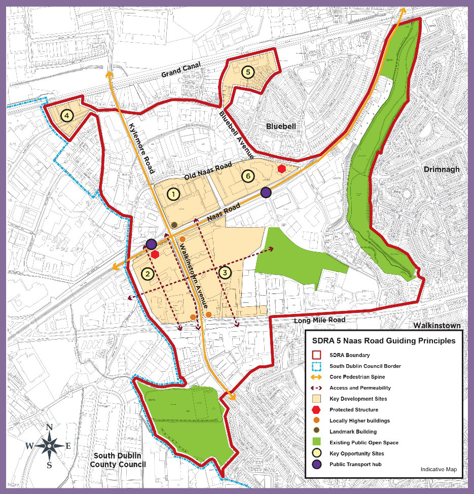
Figure 13-5 SDRA 5 Naas Road
Page: 506, amendments to graphic map
Amendment to Graphic Map:
- Remove KUV boundary from SDRA Map and include new Key Development Site for Naas Road Industrial Estate and surrounding lands and related protected structure symbol.
- Position of north arrow moved from bottom left to top left of graphic map.
- Key Urban Village boundary removed from around Key Opportunity Sites 1, 2 and 3.
- Opportunity site 6 included.
Material Alteration Reference Number 13.17 |
Chapter 13
Section: 13.8 SDRA 6 – Docklands, subheading Green Infrastructure
Page: 512, insert additional bullet point
Amendment:
- {To support and promote that expansion of water-based activities including slipways, pontoons and marinas}
Material Alteration Reference Number 13.18 |
Chapter 13
Section:13.8 SDRA 6 – Docklands, Guiding Principles for Key Opportunity Sites
Page: 516, Site 1. Connolly Station, insert bullet point to the Masterplan requirements
Amendment:
- {Strategy to protect and enhance the character of the existing historic station building}
Material Alteration Reference Number 13.19 |
Chapter 13
Section:13.8 SDRA 6 – Docklands, Guiding Principles for Key Opportunity Sites
Page: 517, Site 5 - Cody’s Yard, Ossory Road
Amendment:
Redevelopment of this site should provide a setback from Ossory Road, enabling a widening of the road to facilitate an improved pedestrian and cycle environment. Own-door access to ground floor dwellings fronting Ossory Road, should also be provided {where feasible, to encourage ground floor activation}. Requirements of Irish Rail shall be adhered to in relation to built footprint and necessary clearances.
Material Alteration Reference Number 13.20 |
Chapter 13
Section:13.8 SDRA 6 – Docklands, 6 – Guiding Principles for Key Opportunity Sites
Page: 518, Site 6 - North Strand Fire Station/Former Readymix Site
Amendment:
All dwellings at ground floor level should have own-door access. Given the scale of this site, (it is appropriate that) a masterplan {shall} be prepared for the entire area to address the above matters in addition to planned phasing.
Material Alteration Reference Number 13.21 |
Chapter 13
Section: 13.8 SDRA 6 – Docklands, Guiding Principles for Key Opportunity Sites
Page: 518, Site 7 – Docklands Innovation Park
Amendment:
Adequate space should be reserved along the south-western boundary of the site for a pedestrian throughway in order to enhance connectivity through this large block, {including to the local school.}
Material Alteration Reference Number 13.22 |
Chapter 13
Section: 13.8 SDRA 6 – Docklands, Guiding Principles for Key Opportunity Sites
Page: 519, Site 8 – Chadwick’s Yard, first paragraph on page
Amendment:
Given the scale of this site, (it is appropriate that) a masterplan {shall} be prepared for the entire area, to address the above matters in addition to planned phasing.
Material Alteration Reference Number 13.23 |
Chapter 13
Section: 13.8 SDRA 6 – Docklands, Guiding Principles for Key Opportunity Sites
Page: 519, Site - 9 - East Road, 2nd paragraph
Amendment:
Given the scale of this site, (it is appropriate that) a masterplan {shall} be prepared for the entire area, to address the above matters in addition to planned phasing.
Material Alteration Reference Number 13.24 |
Chapter 13
Section: 13.8 SDRA 6 – Docklands, Guiding Principles for Key Opportunity Sites
Page: 520, Site - 10 – Castleforbes Business Park, last sentence
Amendment:
Given the scale of this site, (it is appropriate that) a masterplan {shall} be prepared for the entire area, to address the above matters in addition to planned phasing.
Material Alteration Reference Number 13.25 |
Chapter 13
Section: 13.8 SDRA 6 – Docklands, Guiding Principles for Key Opportunity Sites
Page: 520, 1st, 2nd, 3rd 4th paragraphs, Site 11 - Trinity College Innovation District
Amendment:
This site located north of the rail line between Macken Street and Grand Canal Quay, has potential to provide a new hub for innovation, {teaching, research, collaboration, enterprise and support facilities} bridging between the commercial activities in Docklands and research at Trinity College {and enabling the development of a globally competitive innovation district for Ireland}.
(Setbacks on) {The Interface with} Pearse Street shall accommodate a transformed and (widened) public realm, and {on street} parking provision shall be minimal. The existing historic Tower Building (original sugar mill) should be retained and potentially extended vertically by a maximum of 2-3 storeys, and {public realm surrounding the building shall provide physical and visual linkages between the proposed central square and} (generous new public space surrounding the building shall enhance its setting, providing an open aspect to) Grand Canal Quay. The approach to building height and design shall take account of established residential uses to the west and north, and also proximity to the Alto Vetro building. General site heights to range from 7 to 9 storeys with potential for {some} locally higher buildings. (at the three selected positions illustrated in the Guiding Principles Map.)
There is potential for a landmark building/s within this site having regard to the surrounding context and emerging developments in the area.
{The City Council will work closely with TCD and all relevant stakeholders to prepare a Masterplan for the phased development of the site that establishes high quality development objectives and parameters to ensure that an appropriate mix of uses are provided to support a working and resident community including cultural, recreational, retail and related uses.}
(Development of this innovation district shall be in accordance with a masterplan to be agreed with Dublin City Council and addressing phasing in addition to the above matters.)
Material Alteration Reference Number 13.26 |
Chapter 13
Section: 13.8 SDRA 6 – Docklands, Guiding Principles for Key Opportunity Sites
Page: 521, Site 12 – ESB Complex, South Lotts Road, last sentence
Amendment:
Given the scale of this site, (it is appropriate that) a masterplan {shall} be prepared for the entire area, to address the above matters in addition to planned phasing.
Material Alteration Reference Number 13.27 |
Chapter 13
Section: 13.8 SDRA 6 – Docklands, Guiding Principles for Key Opportunity Sites
Page: 522, insert additional text after Site 14 Former Power Station and Pigeon House Hotel, Poolbeg
Amendment:
{15. Shelbourne Stadium, South Lotts Road
The subject site, located in a highly accessible area of the city and comprises of c. 3ha of urban lands suitable for strategic development and regeneration. The lands are capable of delivering a high quality mixed use development to complement and enhance both the existing land uses and future strategic plans for the area.
Any future development of the site should be subject to a Masterplan as part of the planning application process and should provide for a mixed use development comprising of residential, commercial and public open space. The building design and layout should respect the existing buildings to the north along Ringsend Road and the proposed future development of opportunity site 12.
Given the scale of the site, opportunities exist for the provision of some locally higher buildings and landmark buildings addressing the River Dodder.
Permeability interventions should be provided through the site from South Lotts Road to the River Dodder and from Ringsend Road through to opportunity site 12. A feasibility study, including the necessary environmental studies, should be prepared to assess the potential of a pedestrian footbridge across the Dodder connecting Ringsend Village and the Wider Docklands area. A public walkway along the bank of the River Dodder should also be delivered to enhance amenity value of the river at this location.}
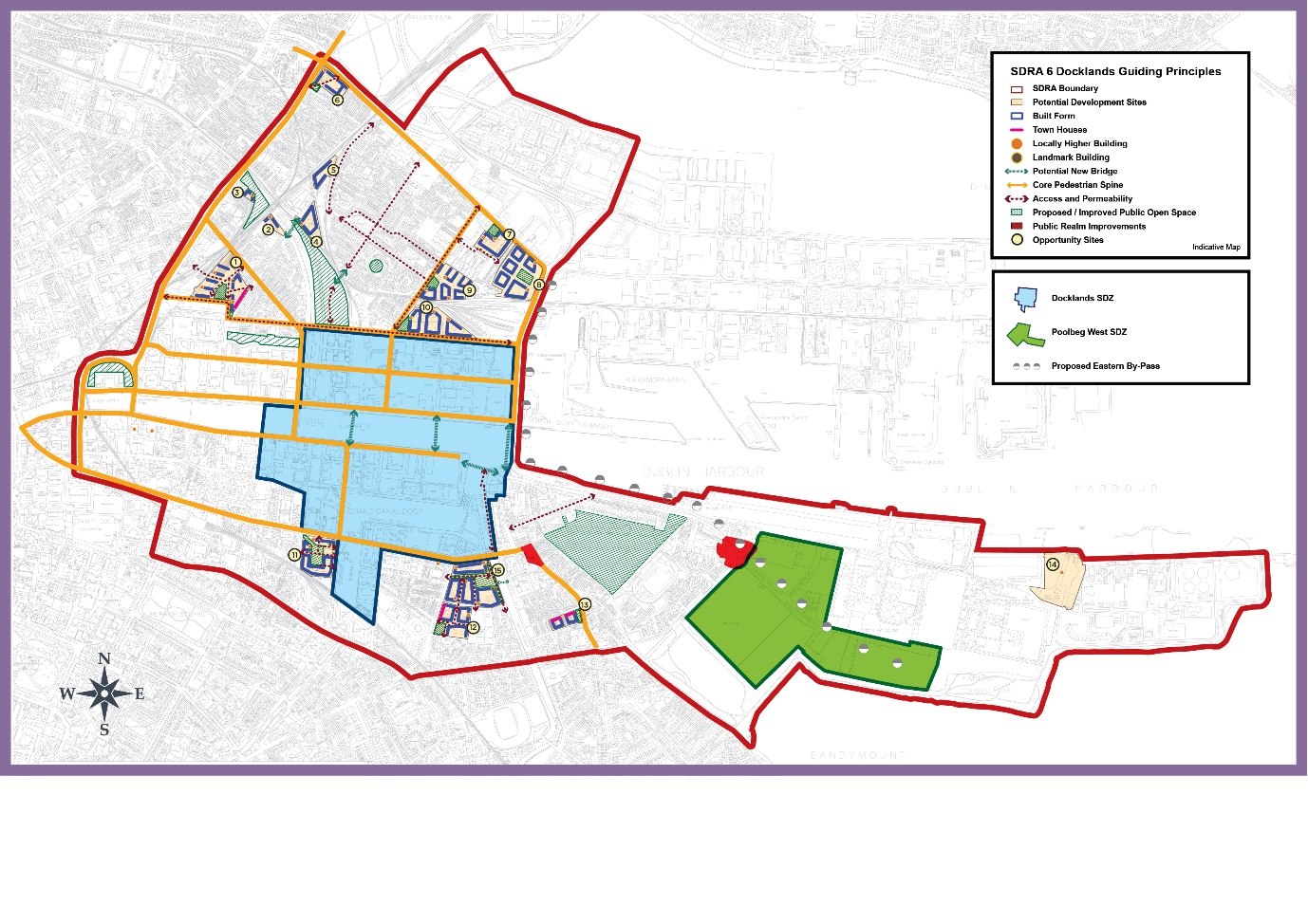
Material Alteration Reference Number 13.28 |
Chapter 13
Figure 13-6 SDRA 6 – Docklands
Page: 523, amendments to graphic map
Amendment to Graphic Map:
- Shelbourne Stadium included as an opportunity site.
- Landmark buildings included at Opportunity site 1, Connolly, Tara Street Station, Opportunity Site 11 – Trinity College Innovation District and Opportunity Site 15 Shelbourne Stadium.
- Locally higher buildings included at Hawkins House, City Quay.
- Colour of “Proposed Eastern By-Pass" symbol in map legend of guiding principles amended from red to grey in guiding principles.
- “Landmark building” symbol included in map legend of guiding principles.
- Opportunity Site 15 newly added to graphic together with built form/public open space/access and permeability/ potential new bridge symbols.
- “Permeability Intervention” guiding principle removed and replaced with “Access and Permeability” guiding principles within Opportunity Sites 1, 6, 7, 11, 12 and 15.
- “Permeability Intervention” guiding principle removed and replaced with “Access and Permeability” guiding principle along east bank of River Dodder within Docklands SDZ.
Material Alteration Reference Number 13.29 |
Chapter 13
Section: 13.9 SDRA 7 – Heuston and Environs, subheading - Height
Page: 526, 2nd bullet point
Amendment:
-
Opportunities exist for landmark buildings at the Heuston Gateway
and, at Sean Heuston Bridge on the former Hickeys site, {and to the west of Steevens Hospital} in line with the considerations outlined in Appendix 3 of the development plan. The potential locations for landmark buildings are shown on the accompanying Guiding Principles Map.
Material Alteration Reference Number 13.30 |
Chapter 13
Section: 13.9 SDRA 7 – Heuston and Environs, Guiding Principles for Key Opportunity Sites
Page: 528, Site 3 – Heuston, 1st paragraph
Amendment:
Given the scale of the site and its redevelopment potential, it is appropriate that in advance of any development proposal, a masterplan {shall} be prepared (and agreed), taking into consideration the wider area, {the SDRA principles and addressing} planned phasing. {This masterplan shall be submitted with the first and subsequent applications for significant redevelopment in the area}.
Material Alteration Reference Number 13.31 |
Chapter 13
Section: 13.9 SDRA 7 – Heuston and Environs, Guiding Principles for Key Opportunity Sites
Page: 529, Site 3 – Heuston, 3rd paragraph
Amendment:
A greening and open space masterplan {shall} (should) also be provided identifying a network of public open spaces including civic squares and parks, throughout the Heuston lands, that are attractive, multifunctional, safe, welcoming and accessible to the wider public.
Material Alteration Reference Number 13.32 |
Chapter 13
Section: 13.9 SDRA 7 – Heuston and Environs, Guiding Principles for Key Opportunity Sites
Page: 529, Site 4 – Heuston South Quarter, 2nd paragraph
Amendment:
Building heights should respond to the ‘Cone of Vision’ identified in the Guiding Principles Map. {During the lifetime of the development plan, a re-assessment of the Cone of Vision shall take place having regard to the national planning context requiring the need to accommodate increased densities on urban brownfield sites, and the landscape character for protection within the cone, such as landmarks, buildings, views, corridors, etc., identified and weighted.}
Material Alteration Reference Number 13.33 |
Chapter 13
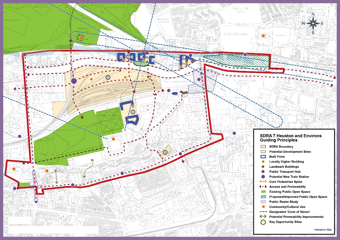
Figure 13-7: SDRA 7 Heuston and Environs
Page 530, amendments to graphic map
Amendment to Graphic Map:
- “Permeability Intervention” guiding principles within Opportunity Sites 2, 3, Phoenix Park Train Tunnel and through Waterloo Avenue at Clancy Barracks removed and replaced with “Access and Permeability” guiding principles.
Material Alteration Reference Number 13.34 |
Chapter 13
Section: 13.10 SDRA 8 – Grangegorman/Broadstone, subheading Introduction
Page: 532, 4th paragraph
Amendment:
The construction of a c. 4,414 m2 Greenway Hub building, a c.16,000m2 East Quad and a c.33,000m2 Central Quad is now complete, accommodating academic activities and facilities required for the Environmental Health Sciences Institute and business incubation space, the College of Arts & Tourism, College of Sciences & Health and College of Engineering and Built Environment. It is anticipated that the TU Dublin developments will provide capacity for a student population of c.15,000 by 2024. {The repurposing of TU Dublin’s Park House continues. It now occupied by c. 10,000 sq. m. of temporary university library and office space.}
Material Alteration Reference Number 13.35 |
Chapter 13
Section:13.10 SDRA 8 – Grangegorman/Broadstone
Page: 533, 2nd paragraph
Amendment:
(By 2023, c.100 bed Residential Care Neighbourhood for the elderly and those with a mental health support needs will be delivered). {It is currently anticipated that by 2025, a c. 100 bed Residential Care Neighbourhood for the elderly, and for those with a mental health support need will be delivered}.Within this timeframe, it is also anticipated that a new 24 Classroom Educate Together National School will be in service, replacing a current temporary facility.
Material Alteration Reference Number 13.36 |
Chapter 13
Section:13.10 SDRA 8 – Grangegorman/Broadstone
Page: 534, insert text after last paragraph
Amendment:
{Prussia Street is located on the western side of the SDRA linking Stoneybatter Village to the North Circular Road. This key thoroughfare provides for significant strategic development opportunities through the regeneration of a number of vacant and underutilised sites for mixed use development. Future development in the area shall provide for a coherent and considered streetscape that respects the existing historic character whilst at the same time ensuring an appropriate scale and density is achieved in line with the 15 minute city objective.
A Masterplan shall be prepared for the area that sets out a clear development strategy including the provision of new permeability routes linking to the wider Grangegorman Campus, a vibrant and active streetscape and the provision of local services and amenities. All developments will be assessed on a case by case in the context of Appendix 3 and the relevant development standards.}
Material Alteration Reference Number 13.37 |
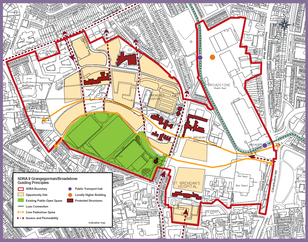
Chapter 13
Figure 13-8:SDRA 8 Grangegorman/Broadstone
Page: 535, amendments to graphic map
Amendment to Graphic Map:
- SDRA boundary amended to include all Prussia Street, Fingal Place and lands along North Circular Road.
- “Permeability Intervention” guiding principle on North Circular Road connecting to SDRA removed and replaced with “Access and Permeability” guiding principle.
- “Permeability Intervention” guiding principle on Grangegorman Road Lower connecting to SDRA removed and replaced with “Access and Permeability” guiding principle.
- “Permeability Intervention” guiding principle connecting to SDRA from Constitution Hill removed and replaced with “Access and Permeability” guiding principle.
Material Alteration Reference Number 13.38 |
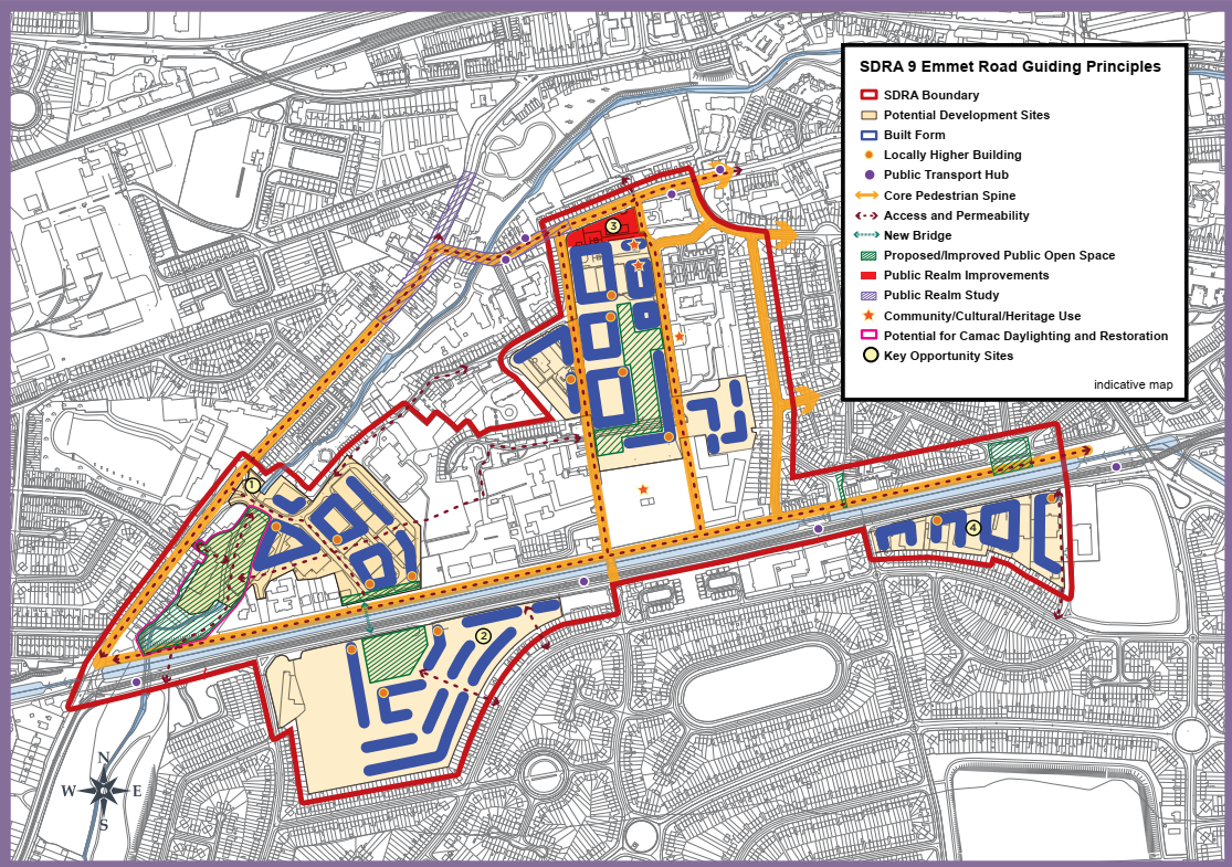
Chapter 13
Figure 13-9: SDRA 9 Emmet Road
Page 541, amendments to graphic map 13-9
Amendment to Graphic Map:
- SDRA boundary amended to include St. John Bosco Youth and Community Centre on Davitt Road.
- “Permeability Intervention” guiding principles in Opportunity Site 1 removed and replaced with “Access and Permeability” guiding principles.
- “Permeability Intervention” guiding principles in Opportunity Site 2 removed and replaced with “Access and Permeability” guiding principles.
- “Permeability Intervention” guiding principles in Opportunity Site 4 removed and replaced with “Access and Permeability” guiding principles.
- North arrow relocated from top left to bottom left corner of graphic map.
Material Alteration Reference Number 13.39 |
Chapter 13
Section: 13.12 SDRA 10 – North East Inner City
Page: 543, insert additional text after d)
Amendment:
- To provide a spatial framework for land uses including much-needed housing.
- To restore a coherent urban structure where it is poor or fragmented and improving the public realm.
- To support community development through targeted objectives on selected sites.
- To plan for improved connectivity and public amenity while utilising existing assets in the area.
- {To support the protection and enhancement of the unique historic character of the area through refurbishment and regeneration of the North Georgian Core}
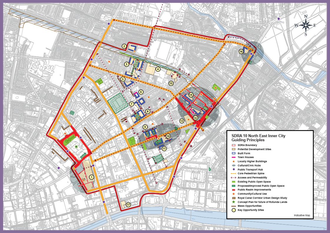
Material Alteration Reference Number 13.40 |
Chapter 13
Section: 13.12 SDRA 10 – North East Inner City, subheading Land Use and Activity
Page: 545, City Gateway Civic Hub
Amendment:
Immediately adjoining the SDRA for the Docklands and serves as an entry point to the inner city and also an access to the employment lands of the Docklands SDRA. It’s positioning on the River Tolka at Annesley Bridge, overlooking Fairview Park, gives the hub capacity for large scale developments. Its regeneration will work in tandem with an identified regeneration site 6 within the Docklands SDRA, where a planned (landmark){locally higher} building will provide a clear visual marker.
Material Alteration Reference Number 13.41 |
Chapter 13
Section: 13.12 SDRA 10 – North East Inner City, Subheading Movement and Transport
Page 549, insert additional bullet point
Amendment:
- {To promote the provision of a station at Croke Park.}
Material Alteration Reference Number 13.42 |
Chapter 13
Section: 13.12 SDRA 10 – North East Inner City, Guiding Principles for Key Opportunities Sites
Page: 550, Site 1 – O’Connell Street to Moore Lane incorporating Carlton Site, 2nd paragraph
Amendment:
Scheme design {shall} (should) be based on a comprehensive masterplan that incorporates a convenient access route to the planned Metrolink stop, quality connections across the site, and a cultural interpretative element.
Material Alteration Reference Number 13.43 |
Chapter 13
Section: 13.12 SDRA 10 – North East Inner City, Guiding Principles for Key Opportunity Sites
Page: 552, Site 2 – Lands to the west of existing Hotel off Jones Road, insert additional text to the end of the 2nd paragraph
Amendment:
{That the provision of community facilities such as a children’s’ playground and/or community garden be incorporated/included in any future development.}
Material Alteration Reference Number 13.44 |
Chapter 13
Section: 13.12 SDRA 10 – North East Inner City, Guiding Principles for Key Opportunity Sites
Page: 552, Site 3 – Russell St/North Circular Road
Amendment:
A masterplan {shall} (will) be {prepared} (required) in relation to proposals on this site, addressing stated requirements and setting out planned phasing.
Material Alteration Reference Number 13.45 |
Chapter 13
Section: 13.12 SDRA 10 – North East Inner City, Guiding Principles for Key Opportunity Sites
Page: 553, Site 4 – Croke Park Lands to the South of Croke Park Stadium, insert additional bullet points to 2nd paragraph
Amendment:
- {To create and implement a quality public realm scheme for Jones’ Road to animate the street, and help provide passive surveillance of the canal.}
- {To examine the feasibility of a station serving Croke Park at this location in conjunction with Iarnród Éireann/Irish Rail}
Material Alteration Reference Number 13.46 |
Chapter 13
Section: 13.12 SDRA 10 – North East Inner City, Guiding Principles for Key Opportunity Sites
Page: 555, Site 10 – Convent Lands, Sean McDermott St.
Amendment:
As a former Magdalene Laundry, it is a site of great historic importance. Its
regeneration and refurbishment should marry the conservation and cultural heritage qualities of the lands with the opportunity to provide activation and renewal of the Railway Street interface, thereby, enhancing public realm. {The area will be the location for a National Centre for Research and Remembrance}. As an integral part of this work, the provision of an appropriate memorial will be investigated with key agencies and stakeholders. An internal garden/courtyard befitting a site of its cultural significance should be designed to be accessible and inviting to the public. Also, two north-south connections through the site should be provided at the locations indicated on the Guiding Principles Map, to tie into the more strategic connections through the area. These should provide throughways that are visible and legible on approach, the routes designed with sufficient width to avoid creation of narrow alleyways. See also CUO9, Chapter 12.
Material Alteration Reference Number 13.47 |
Chapter 13
Section: 13.12 SDRA 10 – North East Inner City, Guiding Principles for Key Opportunity Sites
Page: 557, Site 15 - Lands off Richmond Street North, south of the Royal Canal, insert additional text at end of last paragraph
Amendment:
{The feasibility of a station serving Croke Park at this location in conjunction with Iarnród Éireann/Irish Rail should be examined}.
Material Alteration Reference Number 13.48 |
Chapter 13
Figure 13-10: SDRA North East Inner City
Page 559, amendments to graphic map
Amendment to Graphic Map:
- Reference to permeability intervention at Summer Street North omitted and guiding principles map amended accordingly.
- Reference to potential development site to the rear of Summer Street North and North Great Charles Street omitted by deleting yellow shading. Retain star symbol (community/cultural use).
- All “Permeability Intervention” guiding principles in SDRA 10 removed and replaced with “Access and Permeability” guiding principles.
Material Alteration Reference Number 13.49 |
Chapter 13
Section: 13.13 SDRA 11 – St. Teresa’s Gardens and Environs, subheading: Height, subheading Urban Structure
Page: 561, first paragraph
Amendment:
The potential for further integration with the Coombe Hospital is indicated on the Guiding Principles Map but is indicative only. (Regard will need to be had to any flooding constraints in the redevelopment of the Coombe Hospital lands in terms of land use and block layout.)
Material Alteration Reference Number 13.50 |
Chapter 13
Section: 13.13 SDRA 11 – St. Teresa’s Gardens and Environs, subheading: Height
Page: 562, first and third bullet points
Amendment:
-
In general, the height strategy for the SDRA is that building heights in the range of {3}
(6)-8 storeys will be considered the baseline height for new developments, subject to adequately interacting with the existing building heights adjacent to the subject site. -
The SDRA Guiding Principles Map identifies opportunities for landmark buildings in the order of 15(
-22)storeys to frame the proposed centrally located open space and.....
Material Alteration Reference Number 13.51 |
Chapter 13
13.13 SDRA 11 – St. Teresa’s Gardens and Environs, subheading Design
Page 562, insert additional bullet point to read:
Amendment:
- {Design shall protect the special character of the listed Player Wills factory and its setting.}
Material Alteration Reference Number 13.52 |
Chapter 13
Figure 13-11: SDRA 11 St. Teresa’s Gardens and Environs
Page: 564, amendments to graphic map
Amendment to Graphic Map:
- All “Permeability Intervention” guiding principles in SDRA 11 removed and replaced with “Access and Permeability” guiding principles.
- Landmark building(s) replaced with locally higher building(s).
- North arrow relocated from bottom left to top right corner of graphic map.
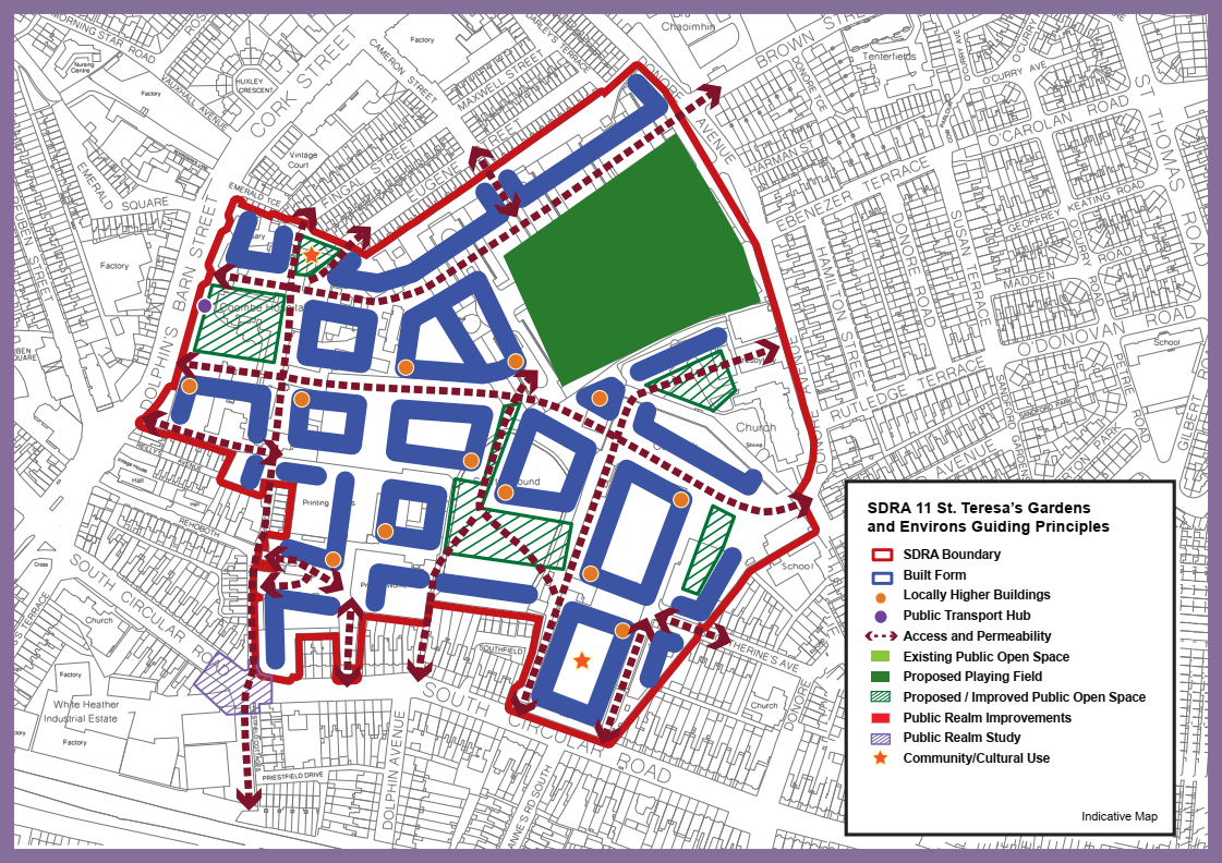
Material Alteration Reference Number 13.53 |
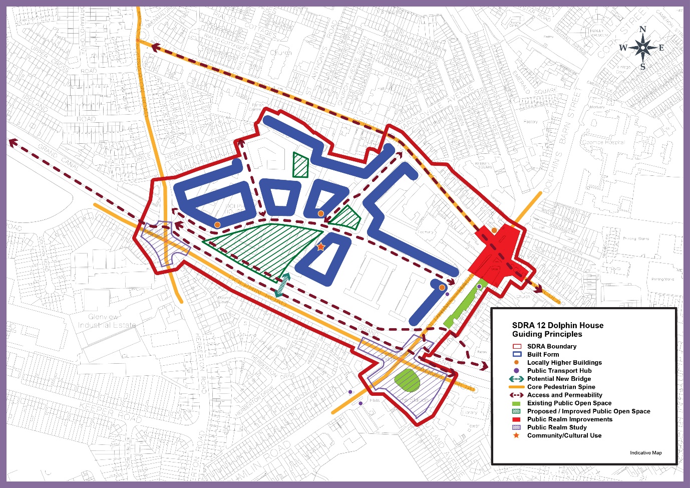
Chapter 13
Section: 13.14 SDRA 12 – Dolphin House, subheading Green Infrastructure
Page: 567, insert additional bullet point
Amendment:
{To support the provision of water based amenities and recreation along the Canal in accordance with GI32.}
Material Alteration Reference Number 13.54 |
Chapter 13
Figure 13-12: SDRA 12 Dolphin House
Page 568, amendments to graphic map
Amendment to Graphic Map:
- All “Permeability Intervention” guiding principles in SDRA 12 removed and replaced with “Access and Permeability” guiding principles.
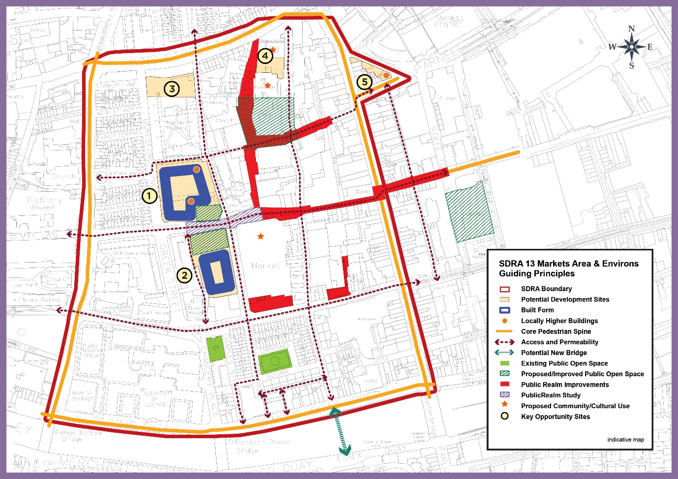
Material Alteration Reference Number 13.55 |
Chapter 13
Section: 13.15 SDRA 13 – Markets Area and Environs, subheading, Urban Structure
Page: 571, insert additional bullet point
Amendment:
- {To recognise the strong character and historic built fabric of the area and support the retention and reuse of existing historic buildings of merit.}
Material Alteration Reference Number 13.56 |
Chapter 13
Section:13.15 SDRA 13 – Markets Area and Environs, Sub Section: Land Use and Activity
Page: 571, 3rd paragraph
Amendment:
Having regard to the above, a framework for redevelopment of underutilised sites needs to demonstrate sensitive integration whilst also generating new vitality. Opportunities for the creation of quality new green/open spaces as part of larger redevelopment projects can supplement existing spaces at Chancery Park, St. Michan’s Park and Ormond Square. There is also considerable scope for public realm upgrades which can both enhance the setting of these spaces and provide quality connections between key destinations. {Opportunities also exist to support casual market trading in appropriate public realm areas subject to appropriate licencing.}
Material Alteration Reference Number 13.57 |
Chapter 13
Section: SDRA 13 Markets Area and Environs, Guiding Principles for Key Opportunity Sites
Page: 575, Site 5 - Ryders Row, 2nd paragraph
Amendment:
With respect to built form and height, it should respond to the prevailing built form, character and grain of the established buildings to its west along Parnell St. However, at the corner it could accommodate a slender building of up to {6-8} (8-10) storeys. Whilst outside the immediate SDRA boundary, the development of this site has potential to signal the route from Parnell Street through to the markets area.
Material Alteration Reference Number 13.58 |
Chapter 13
Figure 13-13: SDRA 13 Markets Area and Environs
Page 576, amendments to graphic map
Amendment to Graphic Map:
- All “Permeability Intervention” guiding principles in SDRA 13 removed and replaced with “Access and Permeability” guiding principles.
Material Alteration Reference Number 13.59 |
Chapter 13
Section: 13.16 SDRA 14 St. James Medical Campus and Environs
Page: 577
Amendment:
Replace St. James Medical Campus and Environs with St. James Healthcare Campus and Environs in all occurrences in the plan.
Material Alteration Reference Number 13.60 |
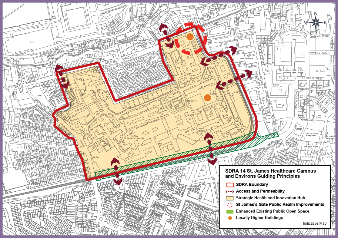
Chapter 13
Figure 13-14: SDRA 14 St. James Healthcare Campus and Environs
Page 581, amendments to graphic map
Amendment to Graphic Map:
- All “Permeability Intervention” guiding principles in SDRA 14 removed and replaced with “Access and Permeability” guiding principles.
- Title of Graphic changed to ‘SDRA 14 St. James Healthcare Campus and Environs Guiding Principles’’.
Material Alteration Reference Number 13.61 |
Chapter 13
Section:13.17 SDRA 15 Liberties and Newmarket Square, subheading Land Use and Activity
Page: 582
Amendment:
- To support the provisions of the Smart D8 project in relation to the provision of a Healthcare Innovation Corridor.
- To {support the provision of community/ cultural uses and} undertake an audit of community infrastructure in the Liberties area in order to identify {additional} community needs.
Material Alteration Reference Number 13.62 |
Chapter 13
Section:13.17 SDRA 15 Liberties and Newmarket Square, subheading Green Infrastructure
Page: 584
Amendment:
-
To support the creation of a public park as part of the regeneration of the Pimlico flat complex.
(involving the consolidation of the Poole St. playing facilities and the existing pocket park at the corner of Earl St. and Thomas Court Bawn.)
Material Alteration Reference Number 13.63 |
Chapter 13
Section: 13.17 SDRA 15 Liberties and Newmarket Square, Guiding Principles for Key Opportunity Sites
Page: 586, Site 2 – Vicar Street, last paragraph
Amendment:
A public realm study should be conducted for the public space identified in the
Guiding Principles Map, with the aim of building upon the planned public realm
improvements for Francis St. and Meath Street {and also addressing potential for sporting and community opportunities in the area.}
Material Alteration Reference Number 13.64 |
Chapter 13
Section: 13.17 SDRA 15 Liberties and Newmarket Square, Guiding Principles for Key Opportunity Sites
Page: 587, Site 5 – Digital Hub, 3rd paragraph
Amendment:
Given the scale of this landholding, (it is appropriate that) a masterplan {shall be} prepared for the entire area, to address the above matters in addition to planned phasing. Any masterplan should also provide for the delivery of enterprise and employment uses in this area.
Material Alteration Reference Number 13.65 |
Chapter 13
Section: 13.17 SDRA 15 Liberties and Newmarket Square, Guiding Principles for Key Opportunity Sites
Page: 588, Site 6 – Marrowbone Lane
Amendment:
It is considered that the SDRA should deliver the objectives for the site including:
-
(The council owned depot at Marrowbone Lane to be developed as a Green Infrastructure and Recreational Area.) - {Consolidation and reduction in area of the existing City Council depot and the regeneration of the wider depot area.}
- Extension of amenity/recreational spaces in association with St. Catherine’s sports centre {and a new public space onto Marrowbone Lane.}
Material Alteration Reference Number 13.66 |
Chapter 13
Section:13.17 SDRA 15 Liberties and Newmarket Square, Guiding Principles for Key Opportunity Sites
Page: 589, Site 9 – Guinness Lands, 1st paragraph
Amendment:
While the operational requirements of the Guinness Lands to the north of Thomas St. are likely to remain beyond the term of the Development Plan, opportunities for smaller parcels of land to be redeveloped may arise in the medium term. {The guiding principles identified for Diageo’s lands north of James’s Street are for consideration as part of any major future redevelopment of the lands and should be designed to be compatible with the operational requirements of the brewery during the lifetime of the development plan.}
Material Alteration Reference Number 13.67 |
Chapter 13
Section: 13.17 SDRA 15 Liberties and Newmarket Square, Guiding Principles for Key Opportunity Sites
Page: 590, Section: 9 – Guinness Lands, 2nd paragraph
Amendment:
Given the scale of these two sites, it is appropriate that in advance of any development proposal, a masterplan {shall be prepared} (and be prepared and agreed for the respective site), taking into consideration the wider area, to address the above matters in addition to planned phasing.
Material Alteration Reference Number 13.68 |
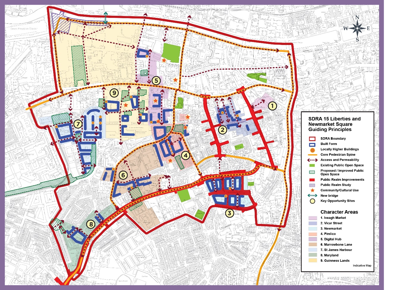
Chapter 13
Figure 13-15: SDRA 15 Liberties and Newmarket Square
Page: 591, amendments to graphic map
Amendment to Graphic Map:
- Guiding principles map amended to omit reference to green infrastructure and recreational area at Marrowbone Lane and included as part of Opportunity site 6.
- “Green Infrastructure and Recreational Area” removed from guiding principles in map legend.
- All “Permeability Intervention” guiding principles in SDRA 15 removed and replaced with “Access and Permeability” guiding principles.
Material Alteration Reference Number 13.69 |
Chapter 13
Figure 13-16: SDRA 16 Oscar Traynor Road
Page: 595, amendments to graphic map
- All “Permeability Intervention” guiding principles in SDRA 16 removed and replaced with “Access and Permeability” guiding principles.

Material Alteration Reference Number 13.70 |
Chapter 13
Section 13.19 SDRA 17 – Werburgh Street, subheading Land Use & Connectivity and Open Space and Amenity
Page: 597
Amendment:
Under Land Use and Connectivity delete:
-
(To recreate the lie of Hoey’s Cuort (the birthplace of Jonathan Swift).) -
To provide a new wall walk (
at Hoey’s Court), looking over Ship Street.
Under Open Space and Amenity, insert additional bullet point:
- {To represent in some form the birth place of Jonathan Swift, (No. 9 Hoey’s Court), one of Ireland’s greatest satirists and authors.}
Clár ábhair
Observations
Observations
13.1 does not include the guiding principle of compliance with the public sector duty in design principles of all the SDRA's
Recommended Comments
Reduce the number of ‘locally higher buildings, which are typically up to 50 metres in height, from twelve to two as per the Adopted 2017...