Please see attached.
Chapter 2: Core strategy
Dúnta25 Sam, 2021, 12:00am - 14 Fea, 2022, 4:30pm
2.1 Introduction
The purpose of this core strategy is to guide the spatial direction of future development and regeneration in the city in line with the principles of compact growth. It accords with the development plan vision as set out in Chapter 1. The Core Strategy is depicted diagrammatically in Figure 2-1. The key objective of the core strategy is to ensure that quantum and location of development is consistent with National and Regional policy.
2.1.1 Legislative Basis
The requirement for a Core Strategy as part of the development plan is described in S10 (2A) of the Planning and Development Acts (PDA) 2000 (as amended). The role of the Core Strategy is to ensure that there is sufficient zoned and serviced land to cater for future housing demand over the development plan period. The Core Strategy sets out a spatial settlement strategy for the city which is consistent with the Housing Strategy, the National Planning Framework (NPF), the Regional Spatial and Economic Strategy (RSES), specific planning policy requirements (SPPRs) required under Section 28 Guidelines and takes account of policies of the Minister in relation to national and regional population targets.
In accordance with the Planning Acts, the Core Strategy is evidence based utilising data based on population trends and household targets. It demonstrates how land already zoned or proposed for zoning will accommodate projected housing demand. The Core Strategy also sets out details of the economic and Retail Strategy for the city so that there is an overall integrated and coherent approach to how the future of the city is planned and that the places people work, live and make use of are interlinked.
Housing Strategy
The Housing Strategy for Dublin City Council is included as Appendix 1 in Volume 2 to the development plan, and includes a Housing Need Demand Assessment (HNDA). A Housing Strategy is a mandatory requirement of the development plan under Part V of the PDA. The purpose of the Housing Strategy is to address the overall housing needs of the existing and future population of the area and the scale and needs for supported housing types. The outcomes from the Housing Strategy inform the Core Strategy and other policies and objectives within the development plan with regard to future housing need.
2.1.2 Policy Context
National Planning Framework (NPF)
The NPF is the Government’s high level strategic plan for shaping the future growth and development of the country to 2040. Compact growth is a key strategic objective of the plan and there is a particular focus on Dublin, with the NPF advocating an approach of consolidation and densification in the city.
This will require focus on a number of large regeneration and redevelopment projects, particularly in respect of underutilised land within the canals and the M50 ring. There is also an emphasis on key Future Growth Enablers for Dublin including a requirement to identify large regeneration sites suitable for housing and employment and aligning development with strategic public transport infrastructure projects.
The NPF provides a series of National Policy Objectives (NPOs), a number of which have informed the Core Strategy, including:
- NPO 3b seeks the delivery of at least half of all new homes to be targeted in the five main cities within their existing built-up footprints.
- NPO 11 states that there will be a presumption in favour of development that can encourage more people and generate more jobs and activity within existing cities subject to development meeting appropriate planning standards and achieving targeted growth.
- NPO no. 72a, no. 72b and no. 73a are considered to be interlinked and largely deal with the NPF ‘tiered approach’ to zoned lands that are serviced, classified as Tier 1: Serviced Zoned Lands; and zoned lands that are serviceable during the life of the development plan, classified as Tier 2: Serviceable Zoned Land (see Section 2.3.4 below).
Regional Spatial and Economic Strategy and Metropolitan Area Spatial Plan
The Eastern and Midlands Regional Assembly (EMRA) prepared the Regional Spatial and Economic Strategy (RSES) in June 2019 for the Eastern and Midlands region; which gives effect to the NPF at regional level. The RSES further endorses the NPF’s principles of consolidation, brownfield development, densification and compact growth. The RSES sets out a new regional plan providing a long term spatial planning direction for the region in which Dublin is categorised as a Global Gateway in recognition of the international role it plays for the country.
Included in the RSES is the 12-20 year Metropolitan Area Strategic Plan (MASP) for Dublin. The MASP identifies a regional framework which aligns population and employment growth with associated transport and infrastructure investment priorities.
In terms of the future growth of the city, the MASP identifies a number of large scale strategic areas based on key transport corridors with a capacity to deliver significant development up to the year 2031. These are defined as Strategic Development Areas and Strategic Employment Lands and the Core Strategy must align with these.
The RSES and MASP also support active land management providing guiding principles to deal with the complexities of brownfield and infill sites in the preparation of the Core Strategy. A key element of the RSES is the population allocation provided for the city. The core strategy aligns with these population figures. This is detailed under Section 2.2 below.
National Transportation Authority - Transport Strategy 2016-2035
The Transport Strategy for the Greater Dublin Area (GDA), prepared by the National Transportation Authority (NTA), provides a framework for a sustainable transport network for the long term. The Core Strategy will promote development and appropriate intensification along the routes of the three key public transport projects to be developed over the development plan period comprising Bus Connects (2021 – 2023), the Metrolink to Dublin Airport/Swords (2021 - 2027) and the Luas to Finglas (2028).
Department of Housing Local Government and Heritage - Section 28 Guidelines
The Department of Housing Local Government and Heritage (DHLGH) published the Housing Supply Target Methodology for Development Planning, December 2020, Projected Housing Demand by Local Authority Area 2020 – 2031 ESRI NPF Scenario Housing Supply Target. It contains housing supply targets for each individual local authority. These housing requirement figures, are used as part of the Core Strategy figures, detailed below under Section 2.2.
The development plan takes into account a suite of other Section 28 planning guidelines in the preparation of the Core Strategy and in relation to a range of policies and objectives incorporated into the development plan. A statement of compliance with such guidelines and associated SPPRs is set out in Appendix 14.
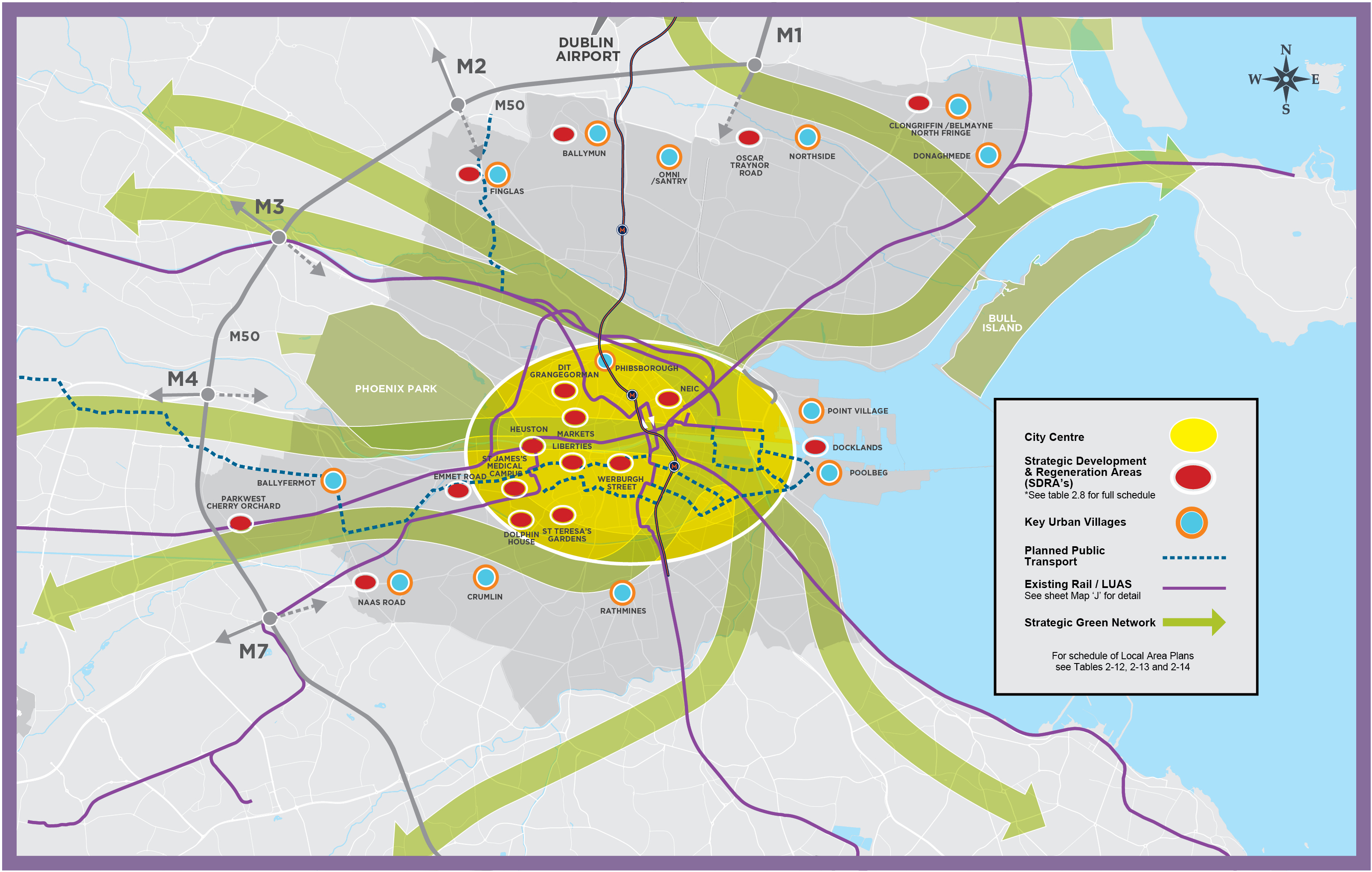
Figure 2-1: Core Strategy Map
2.2 Quantitative Data Underpinning the Core Strategy
This section summarises the key quantitative data used to inform the preparation of the Core Strategy. The two key sets of figures, required to input to the Core Strategy, are population and housing. In this regard, the key data sources are:
- Eastern Midland and Regional Authority: Population Allocation for Dublin City Council (July 2020);
- Department Housing, Local Government and Heritage, Housing Targets for Dublin City Council (December 2020).
The other main sources of quantitative data under this section include an analysis of the Dublin Housing Taskforce (DHTF) Returns for Dublin City Council, which reports on residential planning and construction activity, and the Central Statistics Office (CSO) data on population, housing and employment figures, as interpreted by both ESRI and AIRO. The CSO Census of 2016 (including the most recent CSO annual regional area population projections published August 2020) and the quarterly CSO Local Authority Area New Dwelling Completions also inform the Core Strategy.
2.2.1 Population and Housing Delivery
Population Growth Patterns
The population of Dublin City has increased on average by approximately 5% each inter-censal period between 2006 -2016. The 2006 Census recorded a population figure of 506,211, rising to a recorded population figure of 527, 612 (+ 4.2 %) in 2011 with a recorded population figure of 554,554 (+5%) in Census 2016.
Table 2-1: Population Change
|
Census year |
Population |
% increase |
|---|---|---|
|
2006 |
506,211 |
|
|
2011 |
527,612 |
+4.2% over 5 years |
|
2016 |
554,554 |
+5% over 5 years |
|
2020 CSO population estimate |
595,434 |
7.4% over 4 years |
Source: CSO
The CSO’s 2020 population estimate for the Dublin Region was 1,417,700 persons. Dublin City Council’s share of the 2016 Census regional population figure for Dublin was approximately 42%. Assuming the same share for the CSO 2020 estimated regional population figure for Dublin, this gives an estimated population figure of 595,434 for Dublin City Council in April 2020. This indicates an estimated 7.4 % rise in the population of Dublin City over a four year period from 2016 through to 2020.
Housing Delivery
According to CSO New Dwelling Completions figures for Q1 2017 – Q4 2020, the numbers of new dwellings completed in Dublin City since the adoption of the last development plan was 7,448 units, over a period of four years. Forecasting completions based on 2021 and 2022 estimates, the completions within the full six year period of the last development plan to 2022 is expected to realise approximately 11,708 units.
The Dublin Housing Task Force (DHTF) provides a quarterly update of residential planning and construction activity for the four Dublin Local Authorities. The DHTF figures provide a ‘snapshot’ in time that includes all extant permissions that are ‘live’ at the time the DHTF return is prepared and published. Table 2-2 provides the most recent return at time of writing, and the accompanying Figure 2-2 illustrates the rising volume of permissions and construction activity that has taken place over the past number of years.
Table 2-2: Dublin City Council DHTF Returns Q1 2021
|
Planning Application Stage (Q1 2021) |
No. of Residential Units |
|---|---|
|
Extant Planning Permissions (permitted) |
22,972 |
|
Pending Planning Applications (proposed) |
5,609 |
|
Pre planning application consultation [PACs] (potential) |
23,055 |
Source: DHTF Returns
Figure 2-2: Chart of Dublin City Council DHTF Returns Q1 2017-Q1 2021 - Residential Permissions and on Site Activity
Source: DHTF Returns
As of Q1 2021, there were 22,972 residential units with extant permissions across the city and there were a further 5,609 proposed residential units pending a planning decision. In addition, there were potentially 23,055 residential units at pre planning application consultation (PACs) stage. Prior to the onset of Covid-19, Dublin City was experiencing a surge in construction activity, which was interrupted in 2020. However, current indicators show that construction activity has successfully re-opened and it is expected that future DHTF returns for 2021 and 2022 will demonstrate continued strong growth in housing construction.
Table 2-3: Dublin City Council DHTF Returns Q1 2021- Construction Site Activity
|
Sites |
No. of sites |
No. of residential units |
|---|---|---|
|
Active sites |
70 |
8,559 |
|
Non active sites |
129 |
14,413 |
|
Total |
199 |
22,972 |
Source: Source: DHTF Returns
A recurring pattern in each year is the high volume of extant permissions in comparison to sites under construction. A closer examination of the data, set out in Table 2-4, provides further detail on the uptake of permissions.
Table 2-4: Analysis of Dublin City Council DHTF Returns Q1 2017-Q1 2021 - Ratio of Residential Permissions and on Site Activity
|
Permission / Construction |
Q1 2017 |
Q1 2018 |
Q1 2019 |
Q1 2020 |
Q1 2021 |
|---|---|---|---|---|---|
|
No. Extant Permissions |
8,014 |
10,927 |
11,466 |
18,836 |
22,972 |
|
No. Units Under Construction |
1,924 |
2,695 |
1,914 |
4,334 |
5,316 |
|
Approx. Ratio |
8:2 = 4 |
11:2.5=4.4 |
11.5:2=5.75 |
19:4=4.75 |
23:5=4.6 |
Source: DHTF Returns
From Table 2-3 above, for 2021, permissions for 14,413 residential units has not yet been activated; with this low uptake of permissions now a trend over a number of years. The data shows that the level of extant permissions has more than doubled in a four year period, from approximately 8,000 units in 2017 to over 22,972 in 2021. This analysis demonstrates a trend that notwithstanding the high volume of extant permissions, only approximately one fifth of the permissions granted are being realised on the ground. The reasons for this are many, including the complex nature of site development, acquisition, land speculation and funding models in the city. However, it is also clear that the number of sites becoming active has been increasing over the past number of years demonstrating a generally positive upward trend as shown in Figure 2-3 below.
It is thought that awaiting the adoption of both the Apartment Guidelines (March 2018) and the Height Guidelines (December 2018) may have influenced the timing of commitments on sites during late 2018 and early 2019, as adoption of both, brought certainty and with it, a continued increase in the number of sites becoming active.
Figure 2-3: Chart of Dublin City Council DHTF Returns Q1 2017-Q1 2021 - Active Sites
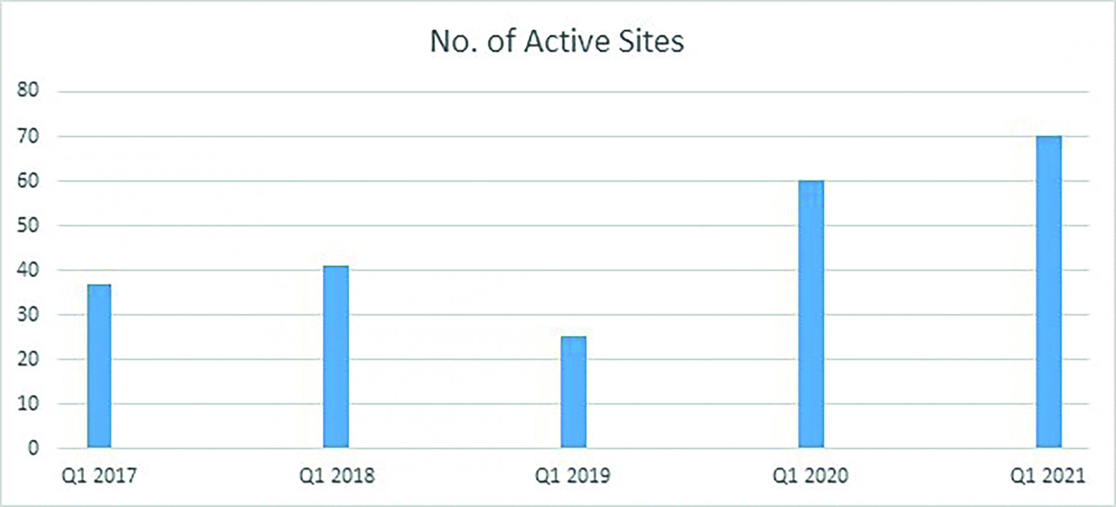
Source: DHTF Returns
2.2.2 Population and Housing Targets
Population Projections for the Core Strategy set out in the RSES and NPF
The NPF identifies a minimum target population of 1,408,000 for Dublin City and Suburbs (including all four Dublin local authority areas) by 2040, representing a 20-25% population growth range from 2016 (see Table 2-5 below).
Table 2-5: NPF Targeted Pattern of City Population Growth for Dublin City and Suburbs[1]
|
Population 2016 |
Population Growth to 2040 |
Minimum Target Population 2040 |
|
|---|---|---|---|
|
% Range |
Number |
||
|
1,173,000 |
20 – 25% |
235,000 – 293,000 |
1,408,000 |
The RSES, guided by the National Planning Framework Implementation Roadmap, sets out population projections for the region for 2026 and 2031. These figures are set out in Table 2-6 below.
Table 2-6: RSES Population Projection for the Dublin City Council Area 2016-2031 (adjusted to comply with NPO 68)
|
2016 (CSO) |
2026 Low |
2026 High |
2031 Low |
2031 High (adjusted) |
|---|---|---|---|---|
|
554,500 |
613,000 |
625,000 |
638,500 |
655,000 |
The Dublin City Development Plan runs from 2022 until 2028. The above figures have been used to extrapolate figures aligning with the development plan period. The adjusted population for Dublin City for the year 2028 is 625,750 (Low) to 640,000 (High) persons.
Housing Supply Targets
The Department of Housing, Local Government and Heritage issued Section 28 guidelines - Projected Housing Demand by Local Authority Area 2020 – 2031 ESRI NPF Scenario Housing Supply Target of S28 Housing Supply Target Methodology for Development Planning, December 2020 - to provide planning authorities with the figures and methodology to incorporate national and regional population and housing projections into their statutory functions.
Table 2-7 below applies the approach prescribed to estimate projected housing demand for the city. The results of this approach identifies the need for 47,941 residential units from 2017 through to 2028 within Dublin City Council, which must then be refined to the development plan period, following the prescribed methodology. Estimated homeless (3,905)[2] is added to this need; and the volume of housing delivered from 2017 to 2020 (11,708) is subtracted. Using this calculation, the Housing Demand for the years 2022 to 2028, the relevant development plan period, is approximately 40,000[3] residential units for the six year period.
Table 2-7: Projected Housing Demand for Dublin City Area 2020 – 2031[4]
|
Table 2-7: Dublin City Council |
Total Households |
Number of Relevant Years |
Annual Average |
|
|---|---|---|---|---|
|
A |
ESRI NPF scenario projected new household demand 2017 to end Q4 2028[5] |
47,941 |
12 |
3,995 |
|
B |
Actual new housing supply 2017 to end Q4 2022 (actual to Q4 2020 and estimated 2021 and 2022 Q1 – Q4) |
11,708 |
6 |
1,951 |
|
C |
Homeless households (June 2021) and unmet demand (as per 2016 Census) |
3,905 |
- |
- |
|
D |
Plan Housing Demand = Total (A-B+C), (Projected ESRI NPF demand – new completions) + Unmet demand |
40,138 |
6 |
6,690 |
Summary
Based on the population targets and calculated housing need set out within national and regional planning policy, guidelines and prescribed methodology, the development plan must accommodate between 21,350 - 31,450 additional persons up to an overall population target of between 625,750 and 640,000 by 2028. The housing demand calculated sets a requirement for the development plan to provide for approximately 40,000 housing units between 2022 and 2028.
2.3 The Core Strategy
This section sets out the key elements that comprise the Core Strategy including an assessment of the location and quantum of appropriately zoned lands available to accommodate the population and housing targets for the city, detailed above. It is a central function of the Core Strategy that it demonstrates that there is sufficient zoned suitable land to meet the requirements of the projected targets.
Climate Change
Central to the entire Core Strategy is the clear purpose of driving forward the steps necessary that deliver climate action. Dublin City is uniquely placed to provide for new housing in locations that fully support sustainable forms of development and allow large numbers of people live, move and work in a way that limits their carbon footprint. City life provides the critical mass that creates the opportunity for people to engage with a wide range of services and social opportunities as well as a work location all within distances that are well served by high quality public transport, premium cycle routes and attractive public realm. This development plan seeks to implement a Core Strategy that continues to build mixed use communities within the city that can sustain and grow a low carbon society (see Chapter 3 for greater detail.) This development plan also seeks to support the principle of "Just Transition" to ensure that no members of society are left behind when transitioning to a zero carbon society.
2.3.1. Land Capacity Assessment
Dublin City Council covers an area of just under 12,000 hectares, with just over 10,000 hectares of land zoned (the remaining unzoned lands comprises of road carriageways, footpaths and rail corridors). The 10,000 hectares of zoned land is divided between the 14 zoning objectives, nine of which can provide for residential use, namely Z1, Z2, Z3, Z4, Z5, Z8, Z10, Z12 and Z14. These nine zoning objectives, in total, make up 5,850 ha of the overall zoned landbank.
A land capacity analysis was carried out by the Planning Department to calculate the yield of undeveloped land; with a particular focus on the 17 Strategic Development Regeneration Areas that are prioritised for development over the development plan period (see also Chapter 13). Of this 5,850 ha of land zoned for residential or mixed (including residential) uses; it has been estimated that there are approximately 550 hectares available to develop during this development plan cycle which can provide approximately 48,500 residential units.

The analysis undertaken demonstrates that Dublin City Council has the capacity to accommodate the required need of 40,000 residential units over the development plan period within its administrative area. The breakdown of this available land and associated housing capacity is detailed in Table 2-8 and Table 2-9 below.
Capacity of SDRA Lands
The SDRA lands are critical to the Core Strategy. All SDRAs (both new and previously identified) have been examined to determine capacity for future housing growth, taking into account sustainable densities and relevant SDZs and LAPs where relevant.
Table 2-8: Capacity of SDRA Designated Lands for Residential Use or a Mixture of Residential and Other Uses
|
SDRA Ref. |
City Area Name |
Estimated Capacity |
Area (HA) |
|---|---|---|---|
|
SDRA 1 |
Clongriffin/Belmayne and Environs |
6,950 -7,350 |
52 |
|
SDRA 2 |
Ballymun |
2,200 - 2,350 |
35 |
|
SDRA 3 |
Finglas Village Environs & Jamestown Lands |
2,800 |
52 |
|
SDRA 4 |
Park West/Cherry Orchard |
2,500 - 3,100 |
49 |
|
SDRA 5 |
Naas Road |
3,300 |
18 |
|
SDRA 6 |
Docklands |
7,900 |
24 |
|
SDRA 7 |
Heuston and Environs |
1,250 |
14 |
|
SDRA 8 |
Grangegorman/Broadstone |
500 |
10 |
|
SDRA 9 |
Emmet Road |
1,050 |
15 |
|
SDRA 10 |
North East Inner City |
850 |
12 |
|
SDRA 11 |
St. Teresa’s Gardens |
950 |
13 |
|
SDRA 12 |
Dolphin House |
350 |
6 |
|
SDRA 13 |
Markets Area and Environs |
400 |
8 |
|
SDRA 14 |
St. James Medical Campus and Environs |
- |
- |
|
SDRA 15 |
Liberties and Newmarket Square |
2,500 |
30 |
|
SDRA 16 |
Oscar Traynor Road |
850 |
17 |
|
SDRA 17 |
Werburgh Street |
100 |
2 |
|
|
Total |
34,350 - 35,550 |
357 |
It is the intent of the Council to monitor and keep under review the Core Strategy and particularly the implementation of the SDRAs during the life of the development plan; and propose changes, if necessary, to secure successful implementation of the Core Strategy.
Capacity of Lands Outside of SDRAs
As part of the preparation of this development plan, a detailed analysis of the zoning maps was undertaken to identify lands that required changes to zonings under four main categories. These included:
- zoning of lands to more appropriate uses to encourage infill development and implement elements of the Z6 Study completed under the 2016 Dublin City Development Plan
- the need to update the zoning where development is now complete;
- the need to amend small scale anomalies and discrepancies and
- the need to amend some community and amenity uses to more appropriate zoning objectives.
This analysis resulted in changes to an area of c. 300 hectares, of which, 200 hectares comprised of the above mentioned nine relevant zoning objectives that provide for housing.
Table 2-9 below sets out the area of existing zoned lands that accommodates both existing and potential new housing i.e. the area of land zoned at the end of the last development plan (including all zoning variations) that will remain zoned under the development plan period from 2022 - 2028. Table 2-9 also sets out the area of land proposed for a change of zoning.
Table 2-9: Summary Table of Existing Zoned Lands with Housing Capacity and Proposed Rezonings
|
2022 – 2028 Plan Period (Existing zoned lands) |
2022 – 2028 Plan Period (Proposed rezonings to existing zoned lands) |
|||||
|---|---|---|---|---|---|---|
|
Relevant zoning Objectives |
Overall Area (Ha) |
Available Area (Ha)*) |
Capacity (residential units) of available area[6] |
Relevant zoning Objectives |
Overall Area (Ha) |
Residential Capacity Estimate |
|
Z1, Z2, Z3, Z4, Z5, Z8, Z10, Z12 & Z14 |
5,850 |
501 |
45,350 |
Z1, Z2, Z3, Z4, Z5, Z8, Z10, Z12 & Z14 |
200 (of which 45 have capacity) |
2,500 |
Taking into account the number of reasons zoning changes have been made (as outlined above); only a portion of the zoning changes have a potential housing capacity. A significant portion of the zoning changes made reflect completions of new developments. These particular zoning changes are unlikely to provide any significant residential yields.
2.3.2 Summary - Total Land Capacity and Zoning Requirements
Table 2-10 summarises the potential capacity of zoned lands within the development plan; combining the SDRA areas with other city lands (including extant permissions and new zonings).
There is zoned capacity for approximately 48,500 units on approximately 550 hectares of developable land within the lifetime of the development plan.
Table 2-10: Total Capacity of City Lands
|
City Area Name |
Estimated Capacity |
Area (HA) |
|---|---|---|
|
SDRA lands |
34,350 - 35,550 |
357 |
|
Other City lands (excluding SDRAs) |
13,000[7] |
189 |
|
Current zoned total |
48,500[8] |
550 |
|
Potential lands at Glasnevin & Naas Road, Phase 1 (see Section 2.3.5) |
6,000 |
|
|
Potential total |
54,500 |
|
Based on this housing capacity, there is evidently sufficient zoned land to meet the needs of the population and housing targets set by the Ministerial Guidelines and the NPF. In addition to this, there are also significant regeneration lands[9] as yet not zoned for housing/mixed use that have potential to deliver additional housing which can be expedited to ensure that the Core Strategy is implemented in the appropriate timescale. For the purposes of clarity, these are included in Table 2-10 as potential lands.
The later phases of these land areas are currently proposed for housing and regeneration beyond the six year life of this development plan. In light of the Government strategy Housing for All, these areas will be considered for variation where they are associated with projects led by Dublin City Council and/or the Land Development Agency; with the Core Strategy updated to remain in accordance with the NPF and RSES.
The Core Strategy Compliance Table, Table 2-11 below, sets out the level of exceedance at approximately 20%. This headroom is considered in line with the 20 – 25% surplus identified in the Draft Development Plan Guidelines, published August 2021.
Table 2-11: Core Strategy Compliance Table
|
Appropriately Zoned Lands Available (Ha) 2022 - 2028 |
Residential Capacity of Available Land (Residential Units) |
Housing Need Demand Requirement (Residential Units) |
Exceedance (%) |
|---|---|---|---|
|
550 |
48,500 |
40,150 |
8,350 (20%) |
In considering the capacity analyses set out above, regard must be had to the historical trends for housing delivery as detailed in Section 2.2.1 above and the fact that there are significant complexities in delivering housing on brownfield lands in urban areas including issues such as economic viability, site assembly and site ownership, funding, timescales for delivering the necessary physical infrastructure and the nature of speculative land management.
The SDRA areas targeted for housing growth in this development plan are aligned to existing and planned public transport corridors and guided by national policy set out in the NPF and RSES. They provide for planned, integrated and sustainable growth over a number of development plan periods for Dublin City Council. Most of the land targeted for new housing in the city is located in SDRAs, which are for the most part, brownfield and regeneration sites. These SDRAs will take long periods of time to be fully delivered, with many running across two development plan cycles to reach completion. To achieve the high quality, integrated approach necessary for successful regeneration, it is critical that the entire envelope of these lands is zoned for development and subject to detailed master-planning and/or local statutory plans that address how they will be delivered over time. This challenge is recognised in the recently published draft Development Plan Guidelines (August 2021). The full build-out of these strategic areas will accord with the timeframes of the RSES until 2031 and the NPF until 2040.
Alongside these strategic lands, there are smaller scale infill opportunities on vacant or redevelopment sites within zoned areas across the city which are likely to come forward during the lifetime of the development plan, and will also play an important role in contributing to meeting the housing targets and this is recognised within the Core Strategy (see Table 2-10, Other City Lands).
2.3.3 Housing Strategy and HNDA
Housing Strategy
A Housing Strategy has been prepared to meet the statutory requirements set out under the Planning and Development Act 2000 (as amended) and in particular, Part V of said Act. The Act requires each planning authority to prepare a housing strategy which will cover the period of its development plan. The Housing Strategy forms an integral part of the Dublin City Development Plan by incorporating national and regional housing policies and housing demand and supply requirements at a local level. The Housing Strategy is set out in Appendix 1.
Following the publication of National and Regional level planning policy, the Housing Strategy is now supported by an evidence-based interim Housing Need Demand Assessment (HNDA).
Housing Need Demand Assessment
HNDA is a tool that is aimed at assisting local authorities to develop long term strategic views of housing need across all tenures, and to provide a robust evidence base to inform policies around housing and to support the preparation of housing strategies. HNDAs are designed to give broad, long-run estimates of potential future housing need, rather than precision estimates. The HNDA is set out in Annex 1 to Appendix 1.
The total housing need figure over the development plan period used in the HNDA is a combination of a household projection scenario (in this case the Convergence Scenario) and an estimate of existing unmet housing need spread over a longer time period; as discussed in the HNDA. It is the policy of the Council to provide fully for the unmet demand during the lifetime of this development plan, whilst recognising that the scale of construction required to meet the target is significant.
The HNDA results in relation to the affordability of housing reflect the impact of rising house and rental prices alongside low levels of construction of both social and private housing over the previous decade.
2.3.4 Tiered Approach and Phasing
The NPF tiered approach under NPO 72a requires a local authority to differentiate between zoned lands that are serviced and zoned lands that are serviceable within the life of the development plan. Dublin City is exceptional in that the entire development plan area is fully zoned and located within the metropolitan area of Dublin. Whilst there may be local infrastructural needs and upgrades needed for certain sites, all lands within the city are capable of being serviced and/or are connected to the public water systems. All are located proximate to public transport networks and public road and cycle routes. A detailed infrastructural capacity assessment is included in Appendix 10.
All SDRA lands, identified in Table 2-8 above are aligned with the RSES strategic development areas. All of these areas have a short to medium term phasing schedule and can be implemented at any time independently, with the exception of the Kylemore Road/Naas Road lands which are given a medium to long term phasing schedule by RSES. This is because the wider Kylemore Road/Ballymount/Naas Road area is significant in scale and requires both significant investment, statutory planning and phasing. The SDRA at the Naas Road (former LAP lands) will be implemented in the short term, reflecting the long standing zoning of this area for regeneration purposes.
2.3.5 Future Development Areas
As part of a major review of Z6 and Z7 zoned lands across the city during the lifetime of the 2016 Dublin City Development Plan, a number of large scale, industrially zoned lands were identified as having significant potential for regeneration as new mixed use communities. A number of these lands were zoned for this purpose by way of variation of the 2016 development plan and have been included in this development plan in the capacity analysis.
Two significant areas identified in the Z6 and Z7 zoned lands study remain mostly zoned Z6 within the development plan:
- Kylemore Road/Naas Road lands and
- Glasnevin (the Dublin Industrial Estate and surrounding lands).
It is the intent of the Council that, following feasibility studies and/or the preparation of a Local Area Plan (or, if designated, a Strategic Development Zone) that these industrial lands will be brought forward as regeneration lands during the lifetime of the development plan.
These land-banks fall under the RSES strategic development areas called ‘Industrial Lands’ where the potential is given as ‘re-intensification of older industrial lands subject to feasibility’. Any feasibility carried out on these lands over the course of the development plan period will include a service capacity investment audit detailing infrastructural requirements to necessitate the densification and intensification of the areas given locational proximity to existing public transport corridors.
The scale and extent of both areas is significant and has great potential to provide high quality new housing and commercial development within the city and to progress the NPF targets for housing delivery on brownfield lands within urban areas. However, there are significant challenges in delivering such lands including provision of physical and social infrastructure, fragmented land ownership and the challenges of implementation. It is likely that the regeneration of these lands will be over a long time frame and the overall impact on the core strategy for this development plan will be limited to the first phases. This possibility has been accounted for in Table 2-10 above. In the face of such challenges, this development plan recognises the importance of good community consultation and will engage with residents on a proactive basis and take on views where applicable. See also Priority LAPs under Section 2.7.1 below for objectives relating to both these areas.
2.4 Settlement Strategy
The Dublin City Settlement Strategy is guided by the policy framework set out at a national and regional level. Dublin City comprises of the central areas and a series of well-established urban villages serving suburban housing located on main transport corridors. This existing pattern of development and movement forms the basis for Dublin’s settlement strategy. Compact growth will be promoted throughout the city through appropriate infill development and consolidation of brownfield sites and targeted growth along key transport corridors.
Broadly, the settlement hierarchy prioritises development in the inner city and the Key Urban Villages. It also specifically targets the Strategic Development and Regeneration Areas, which are primarily brownfield lands located in both inner and outer city areas, where there is capacity to absorb a greater intensification of development owing to their proximity to public transport corridors and supporting urban infrastructure. The SDRA’s align with the Strategic Development Areas, as set out in the Regional Spatial and Economic Strategy for the Metropolitan Area Strategic Plan for Dublin. All SDRAs are accompanied by guiding principles set out under Chapter 13 of the development plan. Some SDRA’s are also governed by an existing LAP or Planning Scheme. In general, a mixed use approach is promoted in the SDRAs, with the objective to create vibrant self-sustaining residential communities served by commensurate social and physical infrastructure as well as commercial development.
The Key Urban Villages (KUV) represent Level 3 Town and /or District centres as per the RSES’s Retail Hierarchy for the Region. This development plan identifies 12 Key Urban Villages for the city, of which five are located on SDRA designated lands including Ballymun, Clongriffin / Belmayne, Finglas, Naas Road and Point Village/Poolbeg. The remaining KUVs are located throughout the city at Ballyfermot, Crumlin Shopping Centre, Donaghmede Shopping Centre, Northside Shopping Centre, Omni, Phibsborough and Rathmines (see also Retail Strategy, Appendix 2).
The settlement strategy is also based on the key principles of healthy place-making and the 15 minute city (see also Chapter 5: Quality Housing and Sustainable Neighbourhoods). The RSES promotes ‘healthy place-making’ which focuses on the delivery of compact and sustainable growth that incorporates well-designed, lifetime adaptable development in close proximity to existing services and facilities.
2.5 Economic and Employment Strategy
The strategy for the city economy and enterprise is to safeguard and enhance Dublin’s role as Ireland’s internationally competitive capital; to promote strategic and targeted employment growth; to support regeneration and tackle vacancy; to support the creation of high quality urban spaces and the transition to a low-carbon, green, circular economy; to support key economic sectors; and to foster local economic development and social enterprise. This approach aligns with the overall goals of NPF, RSES and MASP for the economic development of Dublin City as Ireland’s leading global city of scale (see Chapter 6: City Economy and Enterprise).
The overall approach to the provision of employment lands in the Dublin City area has regard to the role of the city as the country’s most significant employment centre which attracts significant numbers of workers from surrounding local authority areas. The city has seen a significant change in the character of its employment land over the last number of years. Previous low intensity industrial land has in many instances been redeveloped for high quality office use and other more intensive employment land uses. This has been particularly evident in Dublin Docklands. The economic strategy seeks to build on these trends and to continue to support the shift from low intensity, more land-extensive employment uses towards more intensive office, service, retail, tourism and culture related employment activity. In line with the principles of the 15 minute city, the strategy also promotes a more mixed use philosophy, with employment land uses to be developed in conjunction or in close proximity to residential development. In particular, this will be promoted on former industrial Z6 lands, many of which are now zoned Z10, as well as in the SDRAs and Z14 zoned lands and in Key Urban Villages throughout the city.
2.6 Retail Strategy
The Retail Strategy for Dublin City is to consolidate the city centre retail core as the premier retail destination in the State, to promote and consolidate the role of the Key Urban Villages with a level of retail development commensurate to the catchment to cater for surrounding communities. Below this tier, the strategy provides for daily shopping needs and local services for a residential community in urban villages. This approach reflects the settlement strategy for the city and is consistent with the Retail Planning Guidelines (DoECLG, 2012) and the Regional Spatial and Economic Strategy (RSES), Eastern and Midland Regional Assembly (EMRA), 2019 (see Appendix 2: Retail Strategy).
2.7 Implementation
The implementation and delivery of the Core Strategy is a key objective of the City Council. A multifaceted approach will be adopted to support delivery through mechanisms such as plan making and active land management, engagement with other sectors and agencies, as well as monitoring and evaluation measures.
2.7.1 Plan Making
Strategic Development Zones (SDZs)
Dublin City Council has prepared Planning Schemes for three Strategic Development Zones (SDZ), including Grangegorman SDZ, the Docklands SDZ and Poolbeg West.
A Planning Scheme for Grangegorman was approved by An Bord Pleanála in July 2012. This significant re-development project (c. 30 hectares) is managed by the Grangegorman Development Agency, whose role it is to deliver a modern campus for Technology University Dublin (TU Dublin), to provide the Health Service Executive with upgraded primary health and social care facilities and to provide other facilities including a new school and sports grounds for the benefit of the community. Implementation of the SDZ is on-going. When complete, the SDZ will deliver c.380,000 sq. m. of repurposed and new buildings and accommodate a population of c.25,000 people, including c.2,500 staff.
The 2014 approved Planning Scheme for the North Lotts and Grand Canal Dock SDZ is nearing completion. Approximately 400,000 sq. m. of commercial and residential development has been permitted with the vast majority of the lands already complete or under construction.

The government designated SDZ at Poolbeg West Planning Scheme was approved by An Bord Pleanála in April 2019.
It plans for an appropriate mix of housing in order to create a socially balanced community, served by quality amenities and services. Under the Scheme, approximately 3,500 residential units will be delivered. Significant commercial, office and enterprise floorspace (c. 100,000 sq. m.) is also proposed for the area. Applications for infrastructure have already been granted and it is anticipated that these lands will deliver housing during the lifetime of the development plan.
The Council will continue to promote the development and implementation of the three adopted Planning Schemes over the period of the development plan.
Local Area Plans (LAPs) and Village Improvement Plans (VIPs)
Dublin City Council prepares Local Area Plans to deliver the vision, Core Strategy and to coordinate the development of significant new housing/regeneration for the city at a more local level. The function of a Local Area Plan is to set out principles for the future sustainable development of the area, ensuring consistency with the provisions of the Dublin City Development Plan. LAPs are usually required for areas in need of renewal or areas likely to be subject to large-scale development.
Operational LAPs
The Council will continue to implement the LAPs currently in place at the time of adoption of the development plan. The operational LAPs for Dublin City Council are listed in Table 2-12 below.
Table 2-12: List of Operational Local Area Plans
|
Name |
Date of Adoption |
Date of Expiry |
|---|---|---|
|
Ballymun |
October 2017 |
October 2023 |
|
Ashtown/Pelletstown |
December 2013 |
(Extended) December 2023 |
|
Park West - Cherry Orchard |
October 2019 |
October 2025 |
|
Clongriffin-Belmayne |
December 2012 |
(Extended) December 2022 |
|
George’s Quay |
July 2012 |
(Extended) July 2022 |
|
Naas Road |
January 2013 |
(Extended) January 2023 |
Priority LAPs
The rationale for the selection of areas to prepare an LAP is informed by the relevant sections of the Planning and Development Act 2000, as amended; Section 28 Planning Guidelines on Sustainable Residential Development, 2007 and the LAP Guidelines 2013.
The Council proposes three new LAPs to be prepared during the development plan period. These are listed in Table 2-13 below. Both the Naas Road lands and the Dublin Industrial Estate, Glasnevin have been referenced under Section 2.3.5 Future Development Areas above. Both areas present substantial land-banks with significant redevelopment and regeneration potential, requiring a long lead in time to develop a workable framework for delivery as well as significant social and physical infrastructure requirements.
The proposed LAP for the North East Inner City (NEIC) is based primarily on its need for a co-ordinated and planned approach to its future physical redevelopment and importantly its social regeneration. It is an area specifically named in the RSES, resulting in its designation as an SDRA in this development plan.
Table 2-13: Schedule of Local Area Plans to be Commenced over the Plan Period
|
Name of Proposed Local Area Plan |
|---|
|
North East Inner City |
|
Naas Road Lands |
|
Glasnevin, (Dublin Industrial Estate and environs) |
|
It is an Objective of Dublin City Council: |
|
|---|---|
|
CSO1 |
Feasibility Study and Local Statutory Plan for Z6 Zoned Lands at GlasnevinTo prepare a feasibility study and a local statutory plan for the Z6 zoned lands at Glasnevin (Dublin Industrial Estate and environs) in consultation with the relevant stakeholders, including an infrastructural audit with costings and implementation strategy to enable sustainable regeneration and development. |
|
CSO2 |
Local Statutory Plan for lands at Kylemore Road/Naas Road and BallymountTo prepare a local statutory plan in conjunction with South Dublin County Council for lands at Kylemore Road/Naas Road and Ballymount lands to enable a co-ordinated and phased development on these lands over the medium to long term. |
|
CSO3 |
Local Statutory Plan for the North East Inner City (NEIC)To prepare a local statutory plan for the North East Inner City (NEIC) in conjunction with the relevant stakeholders. |
Other Local Areas Plans/Village Improvement Plans (VIPs)
In addition to the above priority list of LAPs to be progressed over the development plan period, it is proposed to prepare a number of other Local Area Plans and/or Village Improvement Plans (VIPs) as set out in Table 2-14 below, subject to resources. The preparation of these plans will be based on a prioritised selection procedure to be agreed during the implementation phase of the plan. Such prioritisation will be on the basis of:
- Areas that require economic, physical and social renewal.
- Development potential and ability to assist in the delivery of the core strategy.
- Need for regeneration within an area based on the Pobal Index of Deprivation.
Table 2-14: Schedule of Other LAPs/VIPs
|
|
Name of Area |
|---|---|
|
1 |
Donaghmede KUV |
|
2 |
Northside KUV |
|
3 |
Phibsborough KUV |
|
4 |
Rathmines KUV |
|
5 |
Santry/Whitehall (incl. Omni KUV) |
|
6 |
Donnybrook |
|
7 |
Drimnagh |
|
8 |
Drumcondra |
|
9 |
Harold’s Cross |
|
10 |
Kilmainham/Inchicore |
|
11 |
Liberties |
|
12 |
Ranelagh |
|
13 |
Ringsend/Irishtown |
|
14 |
South East Inner City |
|
15 |
Stoneybatter |
|
It is an Objective of Dublin City Council: |
|
|---|---|
|
CSO4 |
Programme for the Preparation of Local Area Plans/Village Improvement PlansTo implement a programme for the preparation of Local Area Plans/Village Improvement Plans and to prioritise areas in accordance with the strategic objectives of the Core Strategy including those areas which are experiencing or likely to experience large scale development and regeneration. |
Local Environmental Improvement Plans/Local Strategies
The planning authority may prepare smaller scale plans/strategies such as Local Environmental Improvement Plans (LEIPs), masterplans and local strategies to inform policy/investment and actions at a local scale.
It is considered that this type of non-statutory local based approach that engages with the public and addresses key issues such as movement, public realm, open space, community facilities, education, greening etc., will allow for locally based strategies to be developed that can inform future actions and investment by the Council. Other plans such as ‘The Dorset Street Together Plan’ is an example of a local initiative that could be used to inform the future LEIP for this area.
Local Environmental Improvement Plans (LEIPS) or other appropriate plans will be prepared in collaboration with and consultation with the local area committee, in so far as priorities and resources permit, with the objective of preparing a number of LEIPs for each administrative area taken from Table 2-15 below.
Table 2-15: List of Proposed Local Environmental Improvement Plans (LEIPs)
|
|
Name of Area |
|---|---|
|
1 |
Artane |
|
2 |
Ballyfermot |
|
3 |
Bluebell |
|
4 |
Cabra |
|
5 |
Camac Park |
|
6 |
Chapelizod |
|
7 |
Clontarf |
|
8 |
Crumlin - Kimmage |
|
9 |
Dolphin’s Barn |
|
10 |
Donnycarney, including Malahide Road and Collins Avenue |
|
11 |
Dorset Street |
|
12 |
Glasnevin |
|
13 |
East Wall Area |
|
14 |
Finglas |
|
15 |
Killester Village |
|
16 |
Navan Road |
|
17 |
North Strand – North Strand/Ballybough/Clonliffe |
|
18 |
Sheriff Street/North Wall |
|
19 |
Sandymount |
|
20 |
Terenure |
|
21 |
Walkinstown |
|
It is an Objective of Dublin City Council: |
|
|---|---|
|
CSO5 |
Programme for the Preparation of Local Environmental Improvement PlansTo implement a programme for the preparation of Local Environmental Improvement Plans and to prioritise areas in accordance with the strategic objectives of the Core Strategy. |
2.7.2 Active Land Management
The Core Strategy will be delivered by the implementation of an active land management strategy. Successful active land management involves a multi-layered approach including the incentivisation of development through the implementation of measures such as the vacant site levy and working collaboratively with key stakeholders to achieve core objectives. Funding opportunities such as the Urban Regeneration and Development Fund can also be harnessed to kick start development and enhance development opportunities.
Brownfield and Infill Lands
National and regional policy places an emphasis on compact growth and supports the sustainable development of brownfield and infill lands, through consolidation to support the optimal use of the finite resource of land.
Arising from the active land management strategy, Dublin City Council will prepare, update and monitor brownfield and infill development of a strategic nature throughout the city to actively encourage and support the development of such lands.
|
It is an Objective of Dublin City Council: |
|
|---|---|
|
CSO6 |
Active Land Management Register and DatabaseTo develop an active land management register and database for the city, which shall include mapping of brownfield and other lands, such as vacant, under-utilised or large undeveloped sites, tracking progress on planning applications and identification of barriers to development, with the aim of promoting and co-ordinating development on the lands identified. |
|
CSO7 |
Promote Delivery of Residential Development and Compact GrowthTo promote the delivery of residential development and compact growth through active land management measures and a co-ordinated approach to developing appropriately zoned lands aligned with key public transport infrastructure, including the SDRAs, vacant sites and underutilised areas. |
Vacant Sites Levy/Living City Initiative
Dublin City Council’s Active Land Management Unit established the Vacant Sites Register, under the Urban Regeneration and Housing Act 2015, amended (the Act), on 1st January 2017. The Act provides for a levy on vacant sites and this is a key measure in implementing the Core Strategy.
Vacant development sites are both a challenge and an opportunity for the city to provide for additional housing, employment and other uses. The purpose of the Vacant Site Levy is to activate land that is considered vacant but zoned for uses that could optimise the lands for a more efficient and effective land use management, enabling the realisation of a more compact and consolidated city.
The Vacant Site Levy continues to be implemented within Dublin City Council through monitoring, inspection, site visits and engagement with relevant stakeholders. Chapter 14 of the development plan provides further details on zoning objectives and vacant sites, setting out the criteria under which a site may be deemed vacant.
Another tool is the Living City Initiative (LCI) which is a tax incentive scheme to assist and encourage people to live in the inner city areas of Dublin City. It allows owners and investors to claim tax relief for money spent on refurbishment and/or conversion of residential property. The Living City Initiative unit of Dublin City Council has produced a guide to the LCI tax incentive scheme to help owners and investors to access the scheme and encourage the re-use of buildings in the designated Strategic Special Regeneration Area in Dublin https://www.dublincity.ie/residential/planning/active-land-management/living-city-initiative
|
It is an Objective of Dublin City Council: |
|
|
CSO8 |
Promote Active Land ManagementTo promote active land management including the vacant site levy and the Living City Initiative as a means to encourage brownfield development and densification in the city. |
|
CSO9 |
Vacant SitesTo implement the vacant site levy for vacant development sites as appropriate in the city and to continue to make a publicly available register of vacant sites as set out in the Urban Regeneration and Housing Act, 2015 or any superseding Act. |
|
CSO10 |
Support the Development of Brownfield, Vacant and Regeneration SitesTo prepare, where appropriate, masterplans and other non -statutory plans or strategies to actively encourage and support the development of brownfield, vacant and regeneration sites. |
Derelict Sites/CPO
The Derelict Sites Act 1990 defines a derelict site as any land that detracts, or is likely to detract, to a material degree from the amenity, character or appearance of land in the neighbourhood of the land in question. The Derelict Sites Act continues to be implemented within Dublin City Council through monitoring, inspection, site visits and engagement with relevant stakeholders.
Where the context requires, the use of Compulsory Purchase Orders will be pursued as a possible active land management measure.
|
It is an Objective of Dublin City Council: |
|
|---|---|
|
CSO11 |
Derelict Sites Act and Compulsory PurchaseTo deliver development though the use of the Derelict Sites Act 1990 and through the compulsory purchase of land as part of active land management to achieve the objectives of compact growth and the proper planning and sustainable development of an area. |
Land Development Agency (LDA)
The main functions of the LDA are to coordinate appropriate State lands for regeneration and development, opening up key sites for housing delivery and to drive strategic land assembly from a mix of public and private sources, making these available for housing in a control-led manner with the objective of supporting long-term stability in the Irish housing market. Dublin City Council will liaise, as appropriate, with the Land Development Agency to facilitate the delivery of housing across the city.
2.7.3 URDF Funding
Project Ireland 2040 established various funding mechanisms in order to deliver the objectives of compact growth, including the Urban Regeneration and Development Fund (URDF) which supports sustainable development through the regeneration of cities and large towns. There were eight successful URDF bids by Dublin City Council, during the last development plan, including:
- Rutland Street NEIC (North East Inner City)
- Artists workspaces
- Inchicore / Kilmainham
- Naas Road LAP lands
- Park West/Cherry Orchard Industrial Lands
- Santry River Restoration Project
- North Inner City Concept Area
- South Inner City Concept Area
The Council will continue to harness the potential of such funding schemes to promote and realise the regeneration of the city and the deliver the objectives of the Core Strategy.
|
It is an Objective of Dublin City Council: |
|
|---|---|
|
CSO12 |
Seek Funding for the Delivery of Compact GrowthTo seek funding from appropriate sources including the URDF, to secure the delivery of compact growth and national and regional planning objectives. |
Kilmainham Inchicore Development Strategy (KIDS)
The Kilmainham Inchicore Development Strategy (KIDS) is a non-statutory strategy funded by the Urban Regeneration and Development Fund (URDF). The strategy identifies a number of potential projects including the enhancement of Kilmainham and Inchicore villages, the Camac River Greenway and a Greening Strategy.
The implementation of the KIDS will improve connections between Kilmainham and Inchicore villages, strengthen the quality of the public realm and enhance the landscape character of the area which in turn will act as a catalyst for the urban regeneration of the area.
|
It is an Objective of Dublin City Council: |
|
|---|---|
|
CSO13 |
Kilmainham and Inchicore Development Strategy ProjectsTo seek funding under Call 3 of the URDF for the planning, detailed design and construction of the Kilmainham and Inchicore Development Strategy projects. |
2.7.4 Development Management
Development management will play a leading role in the implementation of the development plan on a site by site basis, ensuring that development applications (planning application, Part 8, Section 5 etc.) are in substantial compliance with policies, objectives, and standards as set out in this development plan.
2.7.5 Enhanced Co-ordination
Implementation of the Core Strategy is essential to achieving the vision set out for Dublin City. Through enhanced engagement and effective co-ordination with the city’s stakeholders including DHLGH, OPR, EMRA, neighbouring local authorities, agencies (NTA, TII, IR, IW, OPW, NPWS etc.) networks, bodies, citizens, and other stakeholders, greater communication on the development plan and its delivery can be established. The Council will continue to utilise mechanisms such as online forums and discussion platforms to engage with stakeholders and communities during the implementation of the development plan.
More specifically, where LAPs or other large development areas, including SDRAs are located adjacent to or within close proximity to a neighbouring local authority, a consultative and collaborative approach will be taken, for example the area of Ashtown /Pelletstown lies in close proximity to Fingal County Council’s Dunsink area, identified in the MASP as a strategic development area for Fingal County Council and the Naas Road land bank straddles the administrative areas of the Dublin City Council and South Dublin County Council.
|
It is an Objective of Dublin City Council: |
|
|---|---|
|
CSO14 |
Co-ordinated Approach to Future Development of Strategic Growth AreasTo facilitate a co-ordinated approach to the future development of strategic growth areas including the Naas Road area, lands at Dunsink and the Belmayne-Clongriffin area, with South Dublin County Council, Fingal County Council respectively and relevant stakeholders. |
2.7.6 Monitoring and Evaluation
A biennial report will be prepared and published to provide an assessment and evaluation of progress on the development plan to date with an opportunity to provide recommendations to amend policy or objectives to align with evaluation of monitoring outcomes. An annual Development Plan Core Strategy Monitoring Report on the City Performance Indicators will also be prepared.
An agreed scheduled programme of works arising from policies and objectives of the plan will be prepared to ensure proactive delivery of same in a timely manner, the progress of which, will be reported as part of the 2 year progress report.
Monitoring of both the Strategic Environmental Assessment (SEA) and Appropriate Assessment (AA), which have informed and guided the policies and objectives in the development plan, will take place periodically but specifically where local plan-making takes place and in the event of any variation proposal during the life of the development plan. For further detail on the monitoring and implementation of the development plan, see Chapter 16.
|
It is an Objective of Dublin City Council: |
|
|---|---|
|
CSO15 |
Progress Report on the Implementation of the Development PlanTo prepare and publish a progress report on the implementation of the development plan within two years from the adoption of the development plan. |

[1] NPF Table 4.1: Ireland 2040
[2]The most recent homeless figures for June 2021 taken together with the overcrowded household figure from Census 2016 to give an updated figure of unmet need (overcrowded and homeless) at 3,905.
[3] Note: this number is rounded from 40,138
[4] Prepared in compliance with Appendix 1 of the Section 28 Guidelines: Housing Target Methodology for development Planning, December 2020
[5] ESRI Baseline Scenario of projected new housing demand from 2017 to Q4 2022 is 47,534; almost in line with the ESRI NPF scenario included above.
[6] The hectarage and capacity figures includes SDRA capacity plus estimated capacity of other lands zoned in the 2016 Plan.
[7] This figure includes the changes of zoning outlined in Table 2-9 added to extant permissions in non-SDRA locations.
[8] Number averaged and rounded for ease of reference.
[9] Section 2.3.5 provides more information on these lands.
Clár ábhair
Observations
Observations
1
2. Core Strategy
2.3.1 Capacity at SDRA Lands
SDRA 9 Emmet Road
“estimated capacity 1050 over...
2. Core Strategy
2.7.1 Plan Making - Other local area plans/ village improvement plans (VIPs)
Welcome the VIP proposed for Kilmainham/...