Nature Conservation and Biodiversity Loss
This plan must address nature conservation in the city in an urgent, comprehensive and meaningful way to ensure that biodiversity loss is halted and...
Chapter 10: Green infrastructure and recreation
Dúnta25 Sam, 2021, 12:00am - 14 Fea, 2022, 4:30pm
10.1 Introduction
The city’s natural assets are an essential resource for conserving biodiversity and for creating a healthy, low carbon, resilient and connected city. They include our parks, open spaces, landscapes, watercourses, coastline and urban tree canopy, some of which have international importance for biodiversity and provide crucial ecosystem services, including flood defences and carbon sequestration. They benefit urban well-being, are an essential part of making healthy places and bolster resilience to the impacts of climate change. Protecting and enhancing the quality of Dublin City’s natural assets and ensuring green, sustainable and climate resilient development will be central to ensuring the liveability of the city and its attractiveness as a place to live, work and visit into the future.
The Environmental Protection Agency has highlighted in its State of the Environment Report[1] the challenges we are facing in Ireland. Aspects of the Irish environment including climate, air, soil and water are not meeting prescribed targets with ecosystems and biodiversity being eroded on an unprecedented scale. The EU Biodiversity Strategy 2030 calls upon cities of the European Union to address biodiversity loss by restoring ecosystems. The UN Decade of Restoration was announced in June 2021. This requires a commitment from cities to increase the percentage of restored and naturalised areas on public land at the city level.
In this respect, it is important to develop a proactive green infrastructure strategy for the city which will balance the need of the city to grow and consolidate with the need to protect and enhance vulnerable natural assets. As part of a green infrastructure approach, the City Council will seek more urban greening, healthy placemaking and development which works with nature in order to lessen the impacts of climate change, improve air and water quality, provide effective flood management, encourage walking, cycling and physical activity generally and also to protect and improve biodiversity and ecological resilience.
10.2 Achievements
The city’s Parks, Biodiversity and Landscape Services Division, continues to plan, design, maintain, and manage the city’s parks and open space resources to best serve the recreational, cultural, economic, environmental and social needs of the city. The first Dublin City Parks Strategy was published in 2019. Year on year, the city continues to achieve Green Flag awards for a number of city parks – including 11 Green Flag awards in 2020. These awards are an international benchmarking standard for parks and open space judged on horticultural standards, biodiversity, cleanliness, sustainability and community involvement. The 2020/1 Covid 19 crisis highlighted the value of our parks as safe places for exercise and social interaction.
The challenges associated with green infrastructure deficits, particularly within the city centre, are being tackled in recent years through the implementation of area-based greening strategies. The first greening strategy commenced in 2015 in The Liberties and, since then, three more have followed: North-East Inner City (NEIC), Stoneybatter and the Markets Area. To date, in the Liberties, new public parks have been developed - Bridgefoot Street Park (10,000 sq. m.) and Weaver Park (4,000 sq. m.) - and most of the historic parks in that area have been refurbished. Within the NEIC since its launch in 2019, the quantum of trees has increased by 20%. Through the Stoneybatter Greening Strategy, a co-design process has led the community to suggest 40 greening projects for the area.
Dublin City Council has prepared a Dublin City Habitat Map (2020), based on a comprehensive database of the habitats of the entire City, to inform and monitor planning and development. This has identified what types of habitats are found in the City, their locations, connectivity and importance.
Dublin City Council was one of the first local authorities in the Republic of Ireland to sign up to the ‘All Ireland Pollinator Plan’ (2015-2020), following on from initiatives over the previous ten years to create wildflower meadows. This has been supported by the gradual ‘wilding’ of parks, road verges and graveyards in order to provide habitat and food for insects and pollinators and through significant changes to planting schemes, which are now comprised of 80% of pollinator-friendly plants, changes in mowing cycles and the elimination of glyphosates from green space management. This work has been brought to the public’s attention through information campaigns and signage with the ‘Leave Them Bee’ tagline.
The development of the Metropolitan Greenway Network connecting Dublin Bay to the wider region / Dublin Mountains is progressing through the city. The completion of Phase 3 of the Royal Canal Greenway (Dublin City Section), the Dodder Greenway and the Clontarf to City Centre Greenway are currently progressing to construction. Phase 4 of the Royal Canal Greenway is currently being planned.
Across the city, the City Council provides a wide range of sporting, leisure and community services that supports communities to stay active and exercise in a safe, positive and accessible manner. Achievements include new/upgraded tennis courts at Bushy Park, St. Anne’s Park, Herbert Park, Rockfield Park, Artane and Courtlands and Whitehall; all-weather pitches and/or astro training surfaces at St. Anne’s Park, Bluebell, Kilbarrack, Rockfield Park, Clongriffin, Brickfields Park, Drimnagh, Donaghmede Park, Hertzog Park and Rathgar; new changing rooms have been provided/upgraded at Tolka River Valley Park, Finglas; Santry River Valley Park, Springdale; Poppintree Park, Ballymun, Markievicz Park and Ballyfermot. To encourage physical activity, the Council has provided new outdoor gyms at multiple locations around the city. These facilities and others represent a significant investment in local parks and provide first class facilities that benefit local communities.
The Dublin City Sport & Wellbeing Partnership (DCSWP) see Dublin City Sport & Wellbeing Partnership, led by Dublin City Council, was established to enable people living and working in the city to participate and engage in sport and physical activity to improve their health and wellbeing. The Partnership works with stakeholders to facilitate sport and physical activity to the city’s communities through the development and implementation of programmes, services and facilities across various demographics. DCSWP was pivotal in cultivating a relationship with parkrun Ireland that now sees the majority of Dublin City’s primary parks utilised every Saturday morning for adult and junior/family park runs.
In making the city more child friendly, new public playgrounds have been completed at Kilbarrack, Sean Moore Park, Sandymount, Le Fanu Park, Ballyfermot, Edenmore Park and Weaver Park, where there was an identified deficit of play facilities in the City Parks Strategy 2019-2022. Many other of the 65 playgrounds in public parks have also been substantially refurbished and improved for universal access and an annual programme of renewal is on-going. A new skate park and playground at Le Fanu Park, Ballyfermot is a particular highlight and success.
10.3 Challenges
The main challenges for protecting, developing and managing the City’s green infrastructure are:
- Mitigating and adapting to climate change: Specific challenges of climate change for Dublin City are examined in the Dublin City Climate Action Plan 2019 and include: decreased biodiversity, impacts of increased flooding, rising temperatures, increasingly higher sea levels, “urban heat island” effects and increases in the frequency and severity of extreme weather events. Dublin City must restore and protect its natural habitats, particularly wetlands and woodlands, so as to reduce its carbon emissions and to increase resilience to the effects of climate change, such as coastal and river flooding.
- Addressing biodiversity loss in the city: In 2019 Dáil Éireann declared a national biodiversity crisis. Ireland’s 6th National Report to the UN Convention on Biological Diversity (2019)[2] called for a transformational change to conserve and restore biodiversity nationally and at EU and a global level. Ireland’s National Biodiversity Action Plan (2017-2021)[3] requires that there is no net loss of biodiversity through the implementation of plans and projects.
- Getting people living and working in the city to be physically active: Ensuring the city facilitates, promotes and supports physical activity in line with the National Physical Activity Plan for Ireland 2016, the Sport Ireland Participation Plan 2021 – 2024 and the Active Cities Project.
- Addressing historic green space deficits in the City Centre and in other parts of the city: Retrofitting green infrastructure into existing built up areas to ensure that our densest urban areas support community access to quality public space and the benefits of green infrastructure.
- Restoring the city’s rivers: Ensuring the city’s rivers attain ‘good ecological status’ in line with the EU Water Framework Directive and providing space for the natural functions of rivers.
- Addressing high levels of soil sealing / impermeable surfaces in the city: Retrofitting nature based solutions including sustainable drainage systems (SuDs) into the city and the public realm.
- Preventing the loss of existing mature trees: There is an ongoing difficulty in retention of existing trees on both public and private lands, due to impacts of development.
10.4 The Strategic Approach
In helping to achieve a healthy, green, connected city and more sustainable neighbourhoods in line with the core strategy of this plan, the following strategic approach will be pursued:
- Creating a climate resilient city by deploying urban greening / nature based solutions to ensure the benefits of ecosystem services [4] are realised within the city. These include green roofs and the planting of suitable tree species in suitable locations as part of sustainable drainage systems (SuDS); constructed wetlands to improve water quality and prevent flash flooding; increased biodiversity; more tree canopy cover to regulate urban heat, improve air quality and provide shade; and corridors for movement of wildlife within the city.
- Providing a network of multifunctional green spaces / urban green spaces which can secure a spectrum of environmental, social, and economic benefits for the city thereby, contributing to urban sustainability, climate resilience and providing a good quality of life for people.
- Providing opportunities for people to get active and lead healthier lifestyles by increasing access to facilities and nature, and by designing spaces / places that enable / encourage active travel, play and physical activity while protecting the environment.
- Creating and reinforcing a climate resilient and robust Urban Forest by planting the right trees in the right locations and by increasing the diversity of species, provenances and age classes. Preservation of mature trees and planting more street trees which will provide wildlife corridors through the most urbanised areas, linking habitats together while providing benefits to people.
10.5 Policies and Objectives
10.5.1 Green Infrastructure
Green infrastructure has a critically important role to play in making Dublin a climate resilient, healthy and green city. Green infrastructure (GI) can be defined as an interconnected network of green space (or blue in the case of water features) that conserves natural ecosystem values and functions and provides associated benefits to human populations[5]. These benefits can be described as ecosystem services and can change over time, and may be potential or realised, depending on human needs. A green infrastructure approach to planning takes into account nature conservation values and actions in concert with land development, growth management and built infrastructure planning.
The city’s green and blue spaces include the coast, parks, rivers, canals, open space areas, public squares, and tree lined streets and increasingly nature based infrastructure such as wetlands in parks, rain gardens in the public realm and green roofs and green walls on buildings. These GI elements perform multiple functions to deliver a wealth of social, environmental and economic benefits to the city (see Table 10.1):
Table 10-1: Examples of Ecosystem Services Provision
|
|
FUNCTIONS |
BENEFITS |
|
Provisioning services |
Through pollination. |
Supporting food production, crops. |
|
Through urban food production and community gardens. |
Support sustainable and local food production. |
|
|
Regulating services |
Providing for climate regulation by sequestering and storing carbon in soil, trees etc. |
Mitigating and adapting the natural and built environment to climate change. |
|
Reducing / slowing down rainwater run-off into our rivers and surface water system and retaining pollutants from entering watercourses |
Improving water quality / flood retention. |
|
|
Providing naturally occurring green infrastructure along the coast to help manage coastal flooding. |
Supporting coastal storm protection sequester pollutants and carbon. |
|
|
Filtering air pollutants as vegetation absorbs and removes particulates. |
Improving air quality. |
|
|
Supporting services |
Increasing the amount and quality of habitats and by providing better connected habitats. |
Supporting resilient ecosystems and biodiversity. |
|
Cultural services |
Enhancing the city’s character and its natural, cultural and heritage elements and by providing places that give a sense of place. |
Providing appealing places in which to live / work / invest / visit. |
|
Providing safe, easily accessible well designed green and civic spaces and streets for social interaction and spaces for recreation at a range of scales and functions. |
Space for physical activity and opportunities for social interaction benefiting people’s health and improving their sense of wellbeing. |
|
|
Providing networks for sustainable travel modes such as cycle routes and paths between spaces and urban centres. |
Enabling active travel and access to nature.
|
Figure 10-1: Existing Strategic Green and Blue Network in Dublin City
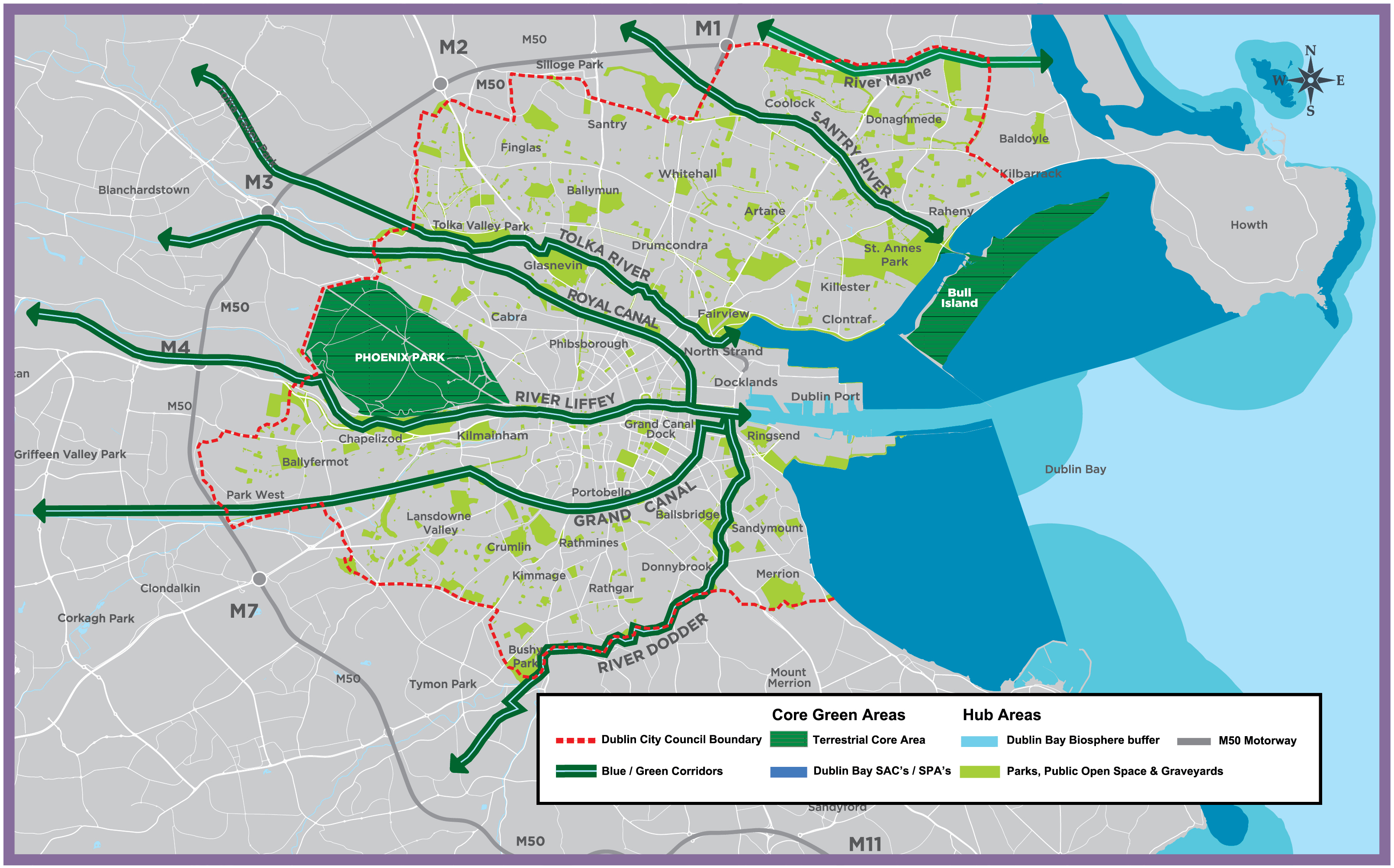
The city’s existing strategic green and blue network shown on Figure 10-1 comprises:
- Core Areas – Dublin Bay and the Phoenix Park - which are the nuclei of the network and provide essential habitat for sensitive species;
- Hubs – parks and open spaces - which buffer the core areas, and are made of the largest, least fragmented continuous natural and semi natural spaces, and,
- Corridors such as the city’s rivers and canals and increasingly our streets and public realm which are vital to maintain connectivity of habitats in the landscape and provide for animal movement, seed and pollen dispersal, and plant migration.
As the city grows and consolidates, a co-ordinated and managed network of multifunctional green spaces linked to the wider regional GI network (as per RPO 7.23 of the Regional Spatial and Economic Strategy 2019), will be required to ensure ecosystem functions are maintained and enhanced. Existing and new developments, streets and the public realm will need to retain natural habitats and existing trees where feasible and also to include increased provision of urban greening features including green roofs, walls and nature based solutions, including sustainable drainage systems (SuDs).
The preparation of a city wide GI Strategy, an action of the DCC Climate Change Action Plan, will strengthen the city’s existing spatial strategic network and will identify strategic opportunities / projects, including for urban place-making and recreational and tourism benefits, for areas of the city such as along the Canals, including the area between Blackhorse on the Grand Canal and the city’s boundary with South Dublin County Council. Green Infrastructure will be delivered through the Development Management process, the planning and development of new growth areas in the city, through LAPs/Planning Schemes, through City Council Greening and Public Realm Strategies (existing and those to be developed) and through public infrastructural projects.
|
It is the Policy of Dublin City Council: |
|
|---|---|
|
GI1 |
Green Infrastructure AssetsTo identify and protect the integrity of the city’s GI assets, as appropriate, and to enhance and expand the connectivity, multi-functionality, and accessibility of the city’s green infrastructure network, while addressing gaps in the network. |
|
GI2 |
ConnectivityTo develop an interconnected green infrastructure network of strategic natural and semi-natural areas with other environmental features including green spaces, rivers, canals, the coastal and marine area and other physical features including streets and civic spaces that supports ecological, wildlife, and social connectivity. |
|
GI3 |
Multi-functionalityTo ensure delivery of multifunctional green and civic spaces that meet community needs, support biodiversity, promote active and passive recreation, flood and surface water management and local habitat improvements. The multi-functionality of spaces will be balanced against the need to protect and enhance local habitat and the recreational and functional requirements of parks. |
|
GI4 |
AccessibilityTo ensure universal design for access for all to the green infrastructure network. Priority of access is to be given to pedestrians over all other users. In line with the Parks Strategy, access to facilities and to public parks and open spaces will be provided equally to all citizens and inequalities of access shall be identified and addressed. |
|
GI5 |
Greening of Public Realm / StreetsTo integrate urban greening features including nature based solutions into the existing public realm where feasible and into the design of public realm projects for civic spaces and streets. The installation of living green walls will be encouraged to the fullest possible extent throughout the city of Dublin. |
|
GI6 |
New Development / New Growth AreasTo integrate Green Infrastructure and an ecosystem services approach into new developments / new growth areas in the city that contributes to the city’s green infrastructure network by its extension and enhancement and that provides for the environmental resilience of new development. |
|
GI7 |
Connecting Greening Elements in Site DesignTo avoid the fragmentation of green spaces in site design and to link green spaces /greening elements to existing adjacent green infrastructure / the public realm where feasible and to provide for ecological functions. |
|
GI8 |
Metropolitan GreenwaysTo support the development of Metropolitan Greenways connecting Dublin Bay to regional and national greenway projects, subject to careful routing and design to ensure ecological functions are maintained and existing biodiversity and heritage is protected and enhanced. The delivery of Metropolitan Greenways is identified in the National Planning Framework as one of the key enablers for the growth of Dublin City. |
|
It is an Objective of Dublin City Council: |
|
|---|---|
|
GIO1 |
Green Roof Guidance Document (2021)The use of green / blue roofs in developments will be in accordance with the requirements of the Dublin City Council Green Roof Guidance Document (2021), see Appendix 11. |
|
GIO2 |
Preparation of a Green Infrastructure Strategy for Dublin CityTo prepare a Green Infrastructure Strategy for Dublin City that will include a newly developed set of green micro areas. |
|
GIO3 |
Current and Future Greening StrategiesTo expand the preparation and implementation of urban greening strategies, with particular focus on key streets in the city area between the Royal and Grand Canals. To support the implementation of the: ‘Liberties Greening Strategy’ (2015), the ‘North East Inner City Greening Strategy’ (2018) and the ‘Stoneybatter Green Strategy’ (2021) and to implement the greening strategies in the Council’s Public Realm Strategies programme. |
|
GIO4 |
Engage with CommunityTo engage with and involve corporate volunteers, landowners and relevant agencies to support their communities in the development and delivery of green infrastructure programmes. |
|
GIO5 |
Design Guide for Public Open SpaceTo implement the forthcoming Dublin City Council Parks, Public Open Space Design Guide. |
|
GIO6 |
Metropolitan and Local GreenwaysTo support the development of the following metropolitan greenways and local cycleways / walkways:
|
10.5.2 Biodiversity
Biodiversity is vital, not just for its intrinsic worth but also because of the wide ranging ecosystem services and social benefits it delivers for our quality of life (our health and wellbeing) and for the social and economic fabric of the city. Biodiversity underpins the city’s green infrastructure. The quality of natural habitats (water, soils etc.) is central to ecosystem services provision, and, therefore, integral to maintaining the integrity of a GI network and the city’s resilience to climate change impacts.
Urban pressures, habitat loss, climate change, pollution, invasive species and human behaviour are some of the constant challenges to conserving and restoring biodiversity. The City Council is committed under the National Biodiversity Plan (2017 – 2021) and the Draft City Biodiversity Action Plan 2021 – 2025 to conserving and restoring this key resource. The Draft Dublin City Biodiversity Action Plan 2021-2025 seeks to address biodiversity loss through targeted actions with measurable outcomes to maintain, restore and supplement nature in the city.
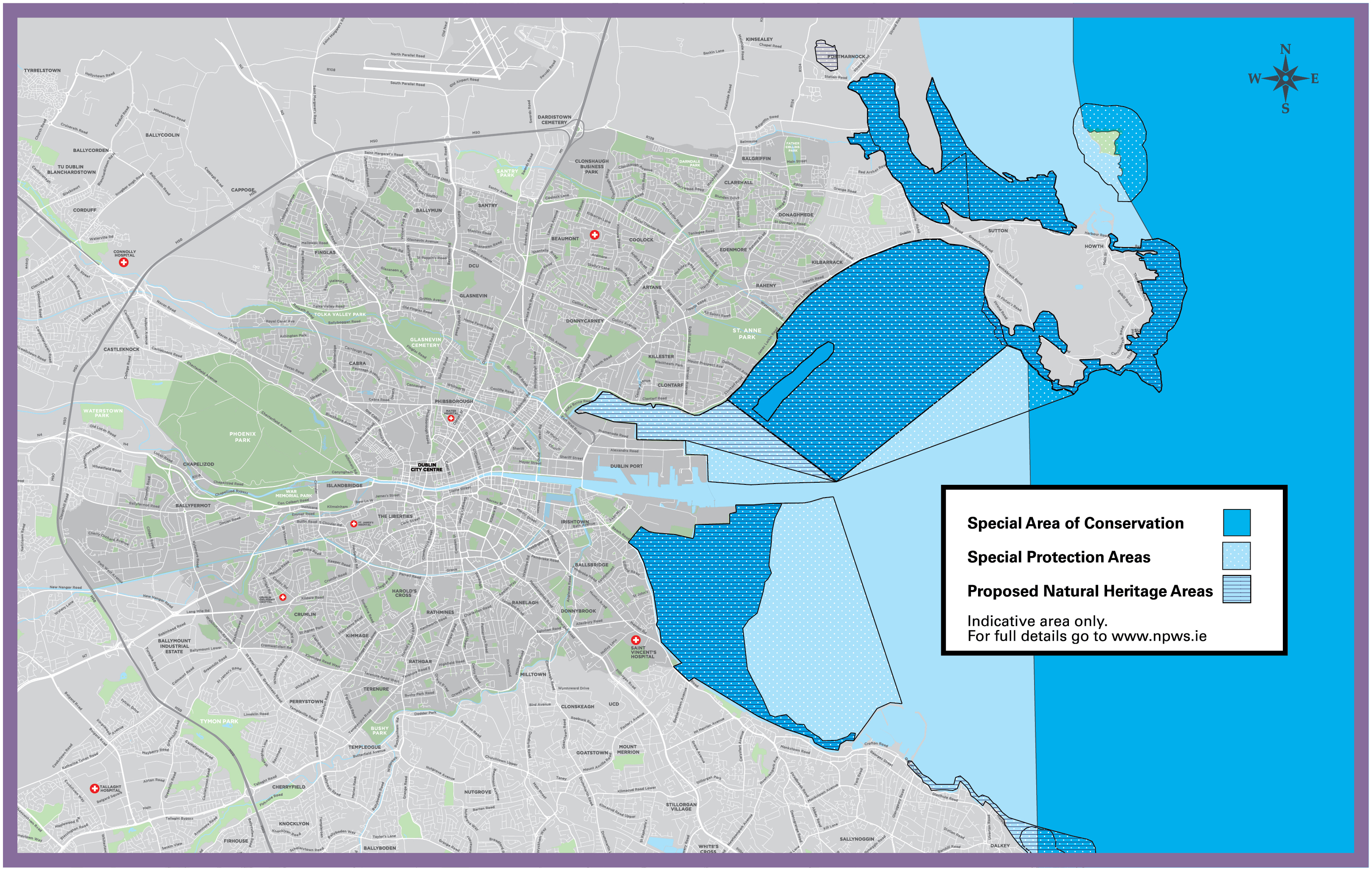
The city has a wide range of habitats which have been mapped. These include natural and semi-natural grasslands, wetlands and watercourses, dunes, woodland and hedgerows, stone walls, street trees, scrub and cultivated ground. Habitats include those within protected areas of international and national importance (see Table 10.2), which in turn, support a wide range of flora and fauna across the city, including protected species (see draft Dublin City Biodiversity Action Plan 2021-2025).
Dublin City Council recognises the importance of inland feeding sites used by protected birds associated with Dublin Bay. All proposals which fall inside, or within the zone of influence of potential disturbance effects, of ex situ inland feeding sites for Special Conservation Interest winter bird species of Special Protection Areas, within Dublin City Council's administrative area, will be subject to an Appropriate Assessment, informed by adequate data to allow assessment of potential effects on the relevant European sites’ conservation objectives. Any such proposals will be assessed and consented in line with the commitment, stated in Chapter 1 (Section 1.5) of this plan, to ensure the legislative requirements for Appropriate Assessment are applied. The draft 2021-2025 Biodiversity Plan contains actions to identify feeding sites within the city and, in respect of its own lands, to develop a grassland management strategy to ensure the availability of the lands as feeding sites for Brent Geese. DCC will also endeavour to work with relevant stakeholders including State and semi-State bodies in this regard.
The preparation of a city wide Green Infrastructure Strategy will facilitate the building of a strong and connected ecological network / corridors. The linking of sites of biodiversity importance in the city including protected sites, wildlife corridors and non-designated sites that have conservation value for biodiversity will enable biodiversity in the city to be more resilient to current and future pressures.
The city has many areas of geological importance, some of which are considered to be of national importance in terms of being best representative examples of particular geological formations or features. The Geological Survey of Ireland (GSI), as part of their Irish Geological Heritage Programme, has identified twelve geological sites of interest in the city. These are: Phoenix Park, River Dodder, North Bull Island, River Poddle, Glasnevin Cemetery, GPO, Museum Building at TCD, Oscar Wilde Statue, 51 St. Stephens Green, Dublin City Walls, Temple Bar Street Well and Guinness Wells.
Table 10-2: Protected Areas of International and National Importance
|
Special Areas of Conservation (SACs) (Natura 2000 sites) |
Special Protection Areas (SPA’s) (Natura 2000 Sites) |
Proposed National Heritage Areas (pNHAs) |
Dublin Bay: Other Designations |
Water Framework Directive Register of Protected Areas |
|
North Dublin Bay (000206) |
South Dublin Bay and River Tolka Estuary (004024) |
North Dublin Bay (000206) |
North Bull Island Ramsar Wetland Site (International) |
Rivers – Abstraction of Drinking Water - River Liffey |
|
South Dublin Bay (000210) |
North Bull Island (004006) |
South Dublin Bay (000210) |
Sandymount Strand/Tolka Estuary Ramsar Wetland Site (International) |
Groundwater Body for abstraction Drinking water – Dublin Urban Groundwater body |
|
SACs and SPAs located in adjoining Counties are shown in the Natura Impact Report (Appropriate Assessment)Volume 6. |
Dolphins Dublin Docks near Pigeon House Harbour (000201) |
North Bull Island National Special Amenity Area |
Bathing Locations – Dollymount, Merrion Strand, Sandymount |
|
|
Grand Canal (002104) |
North Bull Island National Nature Reserve |
Nutrient Sensitive Areas – Rivers Liffey, Liffey Estuary and Tolka Estuary |
||
|
Royal Canal (002103) |
|
Groundwater Terrestrial Dependent Ecosystems– Designated SACs and SPAs |
||
|
It is the Policy of Dublin City Council: |
|
|---|---|
|
GI9 |
European Union Natura 2000 SitesTo conserve, manage, protect and restore the favourable conservation condition of all qualifying interest/special conservation interests of all European sites designated, or proposed to be designated, under the EU Birds and Habitats Directives, as Special Areas of Conservation (SACs) and Special Protection Areas (SPAs) (European / Natura 2000 sites). |
|
GI10 |
Flora and Fauna Protected under National and European Legislation Located Outside Designated AreasTo adequately protect flora and fauna (under the EU Habitats and Birds Directives, the Wildlife Acts 1976–2021, the Fisheries Acts 1959-2006 and the Flora (Protection) Order 2015 S.I No. 356 of 2015), wherever they occur within Dublin City, or have been identified as supporting the favourable conservation condition of any European sites. |
|
GI11 |
Proposed Natural Heritage AreasTo protect and enhance the ecological functions and connectivity of habitats and species of proposed Natural Heritage Areas (pNHAs) to be designated by the National Parks and Wildlife Service (NPWS). |
|
GI12 |
National and International Sites for Nature ConservationTo protect sites for nature conservation as designated under the Ramsar Treaty for wetland sites, National Special Amenity Areas, National Nature Reserves, Important Bird Areas and Flora Protection Order Sites. |
|
GI13 |
Areas of Ecological Importance for Protected SpeciesTo ensure the protection, conservation and enhancement of all areas of ecological importance for protected species, and especially those listed in the EU Birds and Habitats Directives, including those identified as supporting the favourable conservation condition of any European sites, in accordance with development standards set out in this plan. |
|
GI14 |
Ecological / Wildlife CorridorsTo maintain and strengthen the integrity of the city’s ecological corridors and stepping stones which enable species to move through the city, by increasing their connectivity [to be shown in the proposed Green Infrastructure Strategy] under Article 10 of the EU Habitats Directive. Development proposals should not compromise their ecological functions and should realise opportunities to contribute to enhancing the nature conservation value of them by landscaping that provides complementary habitats. An Ecological Impact Assessment will be required for any proposed development likely to have a significant impact on habitats and species of interest on or adjacent an ecological corridor. |
|
GI15 |
Inland and Sea FisheriesTo protect inland and sea fisheries and take full account of Inland Fisheries Ireland Guidelines ‘Planning for Watercourses in the Urban Environment’ 2020, when undertaking, approving or authorising development or works which may impact on rivers streams, watercourses, estuaries, shorelines and their associated habitats. To protect sea angling sites designated by Inland Fisheries Ireland at the North and South Bull Walls and at Dollymount and Sandymount Strands. |
|
GI16 |
Habitat Creation and New DevelopmentThat new development should provide opportunities to incorporate biodiversity improvements through urban greening and the use of nature based infrastructural solutions that are of particular relevance and benefit in an urban context. Opportunities should be taken as part of new development to provide a net gain in biodiversity. |
|
GI17 |
Habitat RestorationTo increase the percentage of restored and naturalised areas on public land in the city. That new development on private and public lands should provide opportunities for restoration of degraded habitats and soils where feasible and provide for their long-term maintenance to limit degradation. |
|
GI18 |
Minimise Impact – Light and NoiseTo minimise the environmental impact of external lighting and noise at sensitive locations to achieve a sustainable balance between the needs of an area, the safety of walking and cycling routes and the protection of sensitive species such as bats (see also Section 9.5.9 Public & External Lighting). |
|
It is an Objective of Dublin City Council: |
|
|---|---|
|
GIO7 |
National Biodiversity Action Plan 2017-2021To support the management targets for nature conservation sites set out in the National Biodiversity Action Plan 2017 (and as updated) and the objectives for local authorities to address threats to biodiversity. |
|
GIO8 |
Draft Dublin City Biodiversity Action Plan 2021 - 2025To support the implementation of the ‘Draft Dublin City Biodiversity Action Plan 2021–2025’ (or as updated), which sets out key themes and objectives for biodiversity conservation and restoration and measurable targets and actions, in partnership with all relevant stakeholders. |
|
GIO9 |
Invasive Alien SpeciesTo support measures to prevent the introduction of and to control the spread of invasive alien species in Dublin City in accordance with the European Communities (Birds and Natural Habitats) Regulations 2011 and EU Regulations 1143/2014 and to implement the targets and actions set out in the Dublin City Invasive Alien Species Action Plan 2016 – 2020 (or as updated). |
|
GIO10 |
All Ireland Pollinator Plan 2021 - 2025To have regard to the all-Ireland Pollinator Plan 2021 – 2025 in the management of the Council’s open spaces, parks and roadside verges and to encourage the pollination of vacant, derelict and temporary sites through measures to protect and increase the populations of native wild bees and other pollinators. |
|
GIO11 |
North Bull Island Management Plan and Nature Reserve Action Plan 2020 - 2025To manage and maintain the North Bull Island National Nature Reserve (Recognition Order, 1988) in partnership with the National Parks and Wildlife Service and to support the implementation of the North Bull Island Management Plan and Nature Reserve Action Plan 2020-2025 for the implementation of Management Objectives. |
|
GIO12 |
Geological SitesTo recognise the importance of County Geological Sites and to protect the character and integrity of these sites / features. |
|
GIO13 |
Dublin City Habitat Map and DatabaseTo protect and improve connectivity of habitats and to prevent habitat loss and fragmentation through urban land use change, development and management through the use of the Dublin City Habitat Map and Database (2020, and updates) to inform planning decisions. |
|
GIO14 |
Further Nature ReservesTo liaise and work with and support the National Parks and Wildlife Service in the designation of additional nature reserves and Natural Heritage Areas, and in the identification of opportunities for nature development.
|
Figure 10-2: SPA/SAC/pNHA Map
10.5.3 Landscape
Dublin’s setting, on the River Liffey and around Dublin Bay, with the Dublin Mountains to the south and Howth peninsula to the north is unique. The city’s natural, historic and dynamic contemporary landscapes define the city and give it its character and identity. This includes the coastal landscape, inland waterways, the city’s historic parks and urban quarters including the Docklands. It is critical to retain existing key landscapes and open spaces which offer so much to the city in terms of amenity and character and which give people a sense of identity and place. Within Dublin City, there are outstanding landscapes of national importance including a National Special Amenity Area at North Bull Island and a National Historic Park – the Phoenix Park.
|
It is the Policy of Dublin City Council: |
|
|---|---|
|
GI19 |
Protect and Enhance LandscapesTo continue to protect and enhance the city’s landscape and seascape, the amenities of places and features of natural beauty and interest, through sustainable planning and design for both the existing community and for future generations in accordance with the National Landscape Strategy 2015 – 2025 and any updated strategy. |
|
GI20 |
Views and ProspectsTo protect and enhance views and prospects which contribute to the appreciation of landscape and natural heritage. |
|
GI21 |
Promote City LandscapeTo promote the city landscapes, including rivers, canals, Dublin Mountains and Dublin Bay, as a major resource for the city and forming core areas of the green infrastructure network. |
|
GI22 |
Managed AccessTo provide managed access to landscape and amenity areas of Dublin city while ensuring their long-term protection and maintenance to limit degradation. |
|
GI23 |
European Landscape ConventionTo continue to protect and enhance landscape, including existing green spaces through sustainable planning and design for both the existing community and for future generations in accordance with the principles of the European Landscape Convention. |
|
It is an Objective of Dublin City Council: |
|
|---|---|
|
GIO15 |
National Landscape Strategy 2015-2025To support and implement the objectives of the National Landscape Strategy 2015 – 2025 (and updates). |
|
GIO16 |
Landscape Character AssessmentTo prepare a Landscape Character Assessment (LCA) for Dublin City, during the lifetime of the plan in accordance with the National Landscape Strategy 2015 – 2025 and the forthcoming National Landscape Character Map and national guidance on local landscape character assessments. |
|
GIO17 |
Views and Prospects StudyTo undertake a ‘Views and Prospects’ study to identify and protect the key views and prospects of the city. Additional views and prospects may be identified through the development management process and local area plans. |
|
GIO18 |
Landscape Conservation Areas ReviewTo investigate the suitability of designating St. Anne’s Park as a Landscape Conservation Area and to prepare a review to examine the potential for other Landscape Conservation Areas as appropriate during the timeframe of the development plan. |
|
GIO19 |
North Bull Island National Special Amenity Area (SAA)To update the 2009 SAAO Management Plan for the North Bull Island National Special Amenity Area. To support the protection of the North Bull Island SAA. |
|
GIO20 |
Liffey Valley & Phoenix Park Proposed SAATo seek the designation of Liffey Valley (from Islandbridge to the western city boundary)and the Phoenix Park as National Special Amenity Areas and to prepare Special Amenity Area Orders (SAAO) for same, in accordance with the Planning and Development Act 2000, as amended. |
|
GIO21 |
Protection and Connectivity of the Dublin Mountains with Dublin CityTo support, as part of the Dublin Mountain Partnership, the proper planning and development measures for the protection and connectivity of the Dublin Mountains with Dublin City. To prepare and implement strategies for the conservation and enhancement of the landscape, visual amenity and biodiversity of the Dublin Mountains, in partnership with South Dublin County Council and Dún-Laoghaire Rathdown County Council. |
10.5.4 Parks and Open Spaces
The City’s parks and open spaces encompass a wide range of spaces including formal parks (Flagship Parks and Community Grade 1 & 2 Parks), green open space areas, grassed areas, woodlands and also cemeteries, allotments and civic spaces. These parks and open spaces play an invaluable role in improving the quality, character and economy of the city. They are an essential physical asset for well-being in the city linked to the better mental and physical health of residents. They provide attractive places for residents, workers and visitors to relax, socialise and play, and allow people to have contact with nature.
According to the Council’s Parks Strategy for the city, parks area per 1,000 population indicates a total provision of 3.64 hectares or 36 square metres per person city wide, and this is comparable with national guidelines. This varies considerably however at the local level and where deficits were identified in the city, greening strategies have been put in place to address these.
As the city develops, the scale, location and connectivity of parks and open spaces need to be planned and designed to better respond to the needs of the growing population. New Flagship Parks and Community Grade 1 and 2 Parks[6] will be provided as part of the delivery of new growth areas in the city. For many other parts of the city, the main emphasis will be on quality and accessibility; ensuring that people have access to good facilities and sufficient recreational space. Opportunities to increase permeability of the urban environment will be sought to increase access to public open space.
Food growing takes place in the city in people’s back gardens, allotments, parks, vacant and temporary sites and on rooftops. Community gardens, allotments and urban farms provide a social, community orientated and physical activity to all age groups and different abilities providing locally grown food. They can also bring vacant lands into active use. Growing space in residential developments, rooftops and temporarily on vacant land and initiatives such as the Eat the Streets (https://www.eatthestreets.ie/dublin) will be fully supported.
|
It is the Policy of Dublin City Council: |
|
|---|---|
|
GI24 |
Multi-FunctionalityTo incorporate new open space into the green infrastructure network for the city, and providing a multi-functional role including: outdoor recreation, biodiversity, urban drainage, flood management, connection and carbon absorption without compromising public access to and the amenity function of open space (see Section 15.6: Green Infrastructure and Landscaping). |
|
GI25 |
Open Space Provision (sq. m.) per 1,000 Persons BenchmarkTo ensure equality of access for all citizens to the public parks and open spaces in Dublin City and to promote more open space with increased accessibility and passive surveillance where feasible. In this regard, a city wide range of 2.5ha to 3.6ha of parks per 1,000 population benchmark for green/recreational space as set out in the 2019 Parks Strategy (or as updated) shall be a policy goal and quality standard. |
|
GI26 |
Securing Acquisition of Additional Public Open SpaceTo give priority to acquiring new public open space on-site, particularly in areas identified in the Council’s Parks Strategy 2019 as deficient in public open space. Where it is not feasible or realistic on site, the Council will require a financial contribution in lieu of provision to provide appropriate open space in the vicinity. The methodology for calculating this contribution shall be included in the City’s Development Contribution Scheme. |
|
GI27 |
Addressing Public Open Space Deficits in Identified AreasTo seek the provision of additional public open spaces in areas of deficiency as identified in the Dublin City Council Parks Strategy 2019 (and any future update) and the forthcoming public open space audit for the city centre by: a) securing open space as part of new development / the redevelopment of brownfield lands; b) the upgrading of existing Flagship Parks and Community Grade 1 & 2 Parks to better serve their communities; c) investigating opportunities for access to local schools and colleges; and, d) the development of pocket parks/parklets. |
|
GI28 |
New Residential DevelopmentTo ensure that in new residential developments, public open space is provided which is sufficient in amenity, quantity and distribution to meet the requirements of the projected population, including play facilities for children and that it is accessible by safe secure walking and cycling routes. |
|
It is an Objective of Dublin City Council: |
|
|---|---|
|
GIO22 |
Dublin City Parks StrategyTo support the implementation of the Dublin City Parks Strategy 2019 or as updated. |
|
GIO23 |
Manage / Protect / Enhance ParksTo continue to manage and protect and/or enhance the city’s parks and public open spaces to meet the social, recreational, conservation and ecological needs of the city and to consider the development of appropriate complementary facilities which do not detract from the amenities of spaces. |
|
GIO24 |
Public Open Space AuditTo support the preparation of a Public Open Space Audit for the City Centre Area. |
|
GIO25 |
Facilities and Amenities in Parks/Public Open SpacesTo continue to provide and improve visitor facilities in parks and public open spaces, including cafés, kiosks, toilets, shower and changing-room facilities, water fountains and dog parks etc. and to ensure that such features are accessibly designed. To encourage and facilitate the introduction of amenities in parks such as table tennis, outdoor gyms, adult exercise equipment, bowling greens, etc. |
|
GIO26 |
Management PlansTo implement Conservation Management Plans for St. Anne’s Park, Merrion Square, Mountjoy Square, Palmerston Park, Herbert Park, Sandymount Green and Wolfe Tone Park and to prepare management plans for all designated flagship parks and Community Grade 1 and 2 Parks under the management of the City Council. It is an objective of the Council to support management plans for the St. Stephen’s Green and the Irish National War Memorial Gardens. |
|
GIO27 |
Phoenix Park Management PlanTo support the implementation of the Phoenix Park Management Plan by the Office of Public Works so as to protect and conserve the historic landscape of the Phoenix Park and its archaeological, architectural and natural heritage whilst facilitating visitor access, education and interpretation, facilitating the sustainable use of the park’s resources for recreation and other appropriate activities, encouraging research and maintaining its sense of peace and tranquillity. |
|
GIO28 |
Urban Farming and Food Production
|
|
GIO29 |
Scully’s FieldTo promote and actively pursue the development of a park in the area known as Scully’s Field between Clonskeagh and Miltown while ensuring the conservation of existing biodiversity. |
|
GIO30 |
Fitzwilliam Square and Four Masters ParkTo seek the opening of Fitzwilliam Square and Four Masters Park at Berkeley Road/Eccles Street to the public. |
10.5.5 Rivers and Canals
The city’s rivers and canals and their riparian zones / towpaths form important elements of the city’s GI network. These waterways and their riparian zones serve as wildlife corridors and aquatic habitats, floodplains, green spaces, the setting for heritage features / development, areas of beauty and tranquillity and a means of connection in the city. Many facilitate river focused amenity, sports and riverside cycle and walkways. The River Liffey is the city’s key waterbody and urban space. It links Dublin Bay to the Phoenix Park and to the wider region and has important civic, amenity, ecological, historical and cultural connections.
The city’s rivers are not achieving ‘good ecological status’ as per the Water Framework Directive. This is due to a number of factors including upstream pollution, sewer overflows / misconnections and urban runoff. In addition, urban development and historic alterations to rivers has altered the natural banks and contours of river valleys and thus allowed for the rapid and increased movement of water/pollutants into rivers leading to the loss of water quality, biodiversity and increasing the potential for flooding.
Figure 10-3: Dublin City’s Main Rivers and Canals
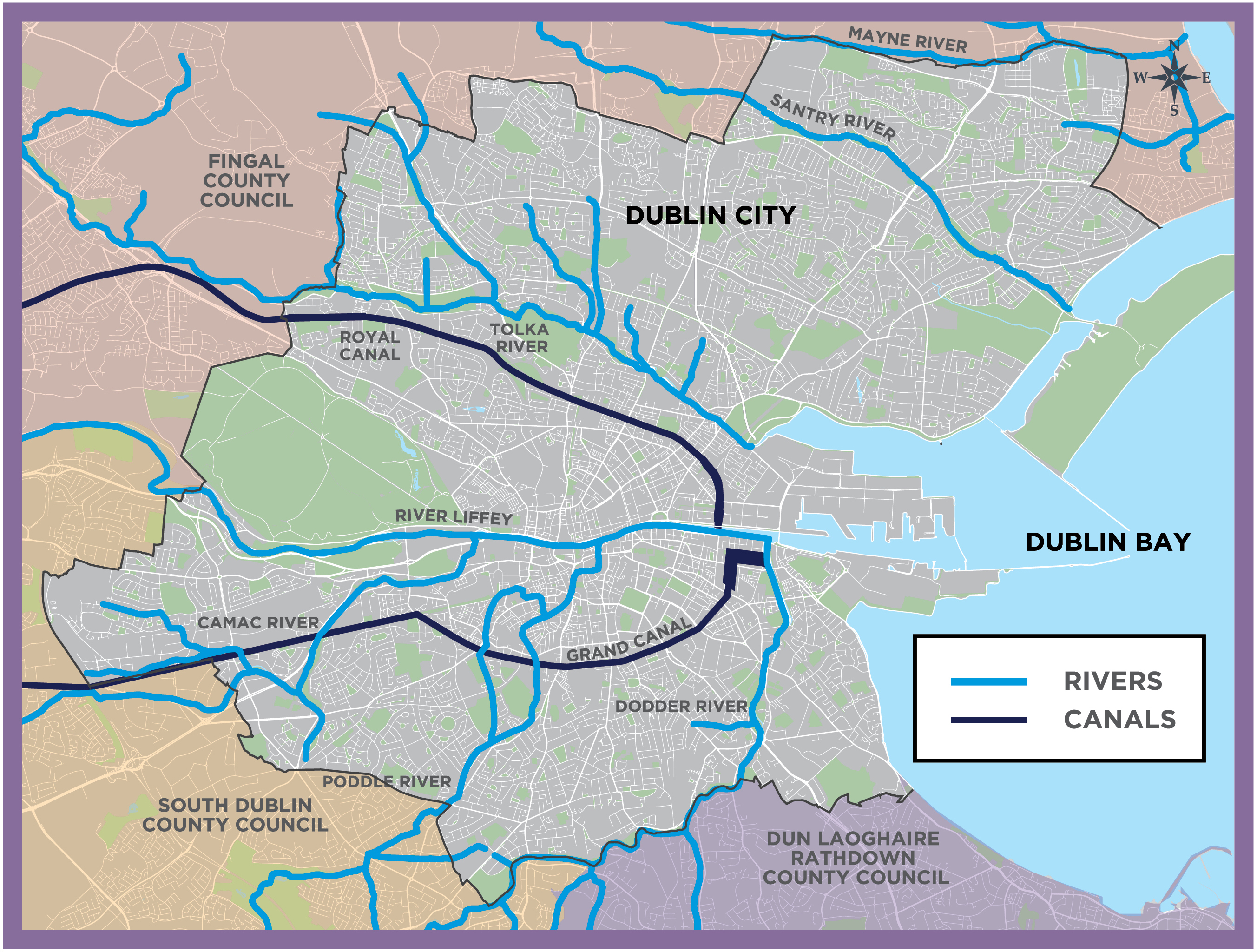
The protection, creation and/or enhancement of riparian buffer zones will be sought to benefit rivers as will opportunities for river restoration. Such interventions will maintain or create habitats necessary for wildlife movement, including fish and other aquatic life and terrestrial species that use the riparian zones as wildlife corridors. This will also increase the potential to filter out pollutants and sediments from over-land surface run-off, provide significant amenity and recreational value, and enhance flood management (see also Chapter 9, Section 9.5.2).
|
It is the Policy of Dublin City Council: |
|
|---|---|
|
GI29 |
Protect Character of River CorridorsTo protect, maintain, and enhance the watercourses and their river corridors in the city and to ensure that development does not cover or encroach upon rivers and their banks. To maintain natural river banks and restore them as part of any new development. The creation and/or enhancement of river corridors will be required and river restoration opportunities where possible will be supported to help improve water quality, and ecology, provide natural flood relief as well as providing amenity and leisure benefits. |
|
GI30 |
Maintain and Improve Connectivity of Freshwater and Estuarine Habitats/ EU Birds and Habitats DirectivesTo conserve, maintain and restore freshwater and estuarine habitats which are of importance for species listed in the annexes of the EU Birds and Habitats Directives and to ensure connectivity of these in accordance with Article 10 of the EU Habitats Directive. |
|
GI31 |
Protect and Improve Ecological Status of Rivers under the EU Water Framework DirectiveTo support the improvement of the ecological status of all rivers / waterbodies within the administrative area of Dublin City Council and those rivers identified in accordance with the River Basin Management Plan 2018 – 2021 and the next management plan to be produced under the 3rd river basin planning cycle (2022-2027), as required under the EU Water Framework Directive (see Chapter 9, Section 9.5.2 Urban Watercourses and Water Quality). |
|
GI32 |
Linear Parks and Recreational Use of Waterways AspectsTo develop linear parks, sustainable riverine access, walkways, cycleways and water focused recreational, sporting and tourism amenities which enhance appreciation of rivers in a manner that ensures that any adverse environmental effects are avoided and ecological enhancements, where appropriate, are employed to ensure a net biodiversity gain. Where lands along the waterways are in private ownership, it shall be policy in any development proposal to secure public access along the waterway. |
|
GI33 |
River LiffeyTo recognise the unique character, importance and potential of the River Liffey to the city and to protect and enhance its civic, ecological, amenity, historical and cultural connections. To promote the sustainable development of this key resource for amenity and recreational uses in and along the river and its development as a green corridor in the city. |
|
GI34 |
New Development and Public Open Space along River CorridorsTo ensure that new development, in terms of siting and design, responds to the character, importance and setting of the city’s rivers where the context allows, and to require public open space which is to be provided as part of new development, to supplement riparian buffer zones so as to support the attainment of ‘good ecological status’ or higher for water bodies, flood management, the conservation of biodiversity and ecosystem functions. |
|
It is an Objective of Dublin City Council: |
|
|---|---|
|
GIO31 |
North City WalkTo investigate the potential of the North City Walk from the Royal Canal linking all the main natural and built heritage sites between the Royal Canal and the Tolka River. |
|
GIO32 |
Liffey Vale House Education CentreTo develop an accessible biodiversity and education centre at Liffey Vale House for education and interpretation of the River Liffey, its ecosystem, history and culture. |
|
GIO33 |
Working with AgenciesTo liaise and work with relevant State agencies responsible for the city’s waterways, including Waterways Ireland, Inland Fisheries Ireland, the Environmental Protection Agency, the Office of Public Works (OPW), The Local Authority Waters Programme (LAWPRO) and Dublin Port Company. |
|
GIO34 |
Water Animation Strategy DocklandsTo support the implementation of the North Lotts and Grand Canal Dock SDZ Docklands Water Animation Strategy 2018 to promote the Dublin Docklands as a significant water focussed amenity and the sustainable use of the waterways as an integral part of the vitality and experience of Dublin Docklands, that enhances the area as a world class destination for living, doing business, tourism, leisure and cultural activities. |
10.5.6 The Coast and Dublin Bay UNESCO Biosphere
Dublin’s coastline is an important asset for the city as it underpins many of the environmental, economic, recreational, cultural and tourism functions of the City. Dublin Bay encompasses coastal landscapes, coastal amenities, natural heritage of international, European and national importance, nature reserves and recreational opportunities. It is also home to coastal settlements, Dublin Port and much of the critical infrastructure for the city which is extremely vulnerable to climate change. The future economic, tourism, recreational (including water based activities such as sea swimming) and energy resource potential of the coast will need to be balanced with the requirement to protect its natural heritage, water quality and attractions.
Dublin Bay and its hinterland is designated since 2015 as a UNESCO Biosphere Reserve. Biosphere reserves promote solutions reconciling the conservation of biodiversity with its sustainable use. They are learning areas for sustainable development which integrate three main "functions": 1) conservation of biodiversity and cultural diversity; 2) sustainable economic development; and 3) logistic support, underpinning development through research, monitoring, education and training. The UNESCO Biosphere is managed through the Dublin Bay Biosphere Partnership which comprises Fingal County Council, Dublin City Council, Dún Laoghaire-Rathdown County Council, Dublin Port Company, Fáilte Ireland and the National Parks and Wildlife Service. Their work focuses on the inter-relationship between the human, cultural and ecological aspects of Dublin Bay (see Dublin Bay Biosphere).
EU Directive 2014/89/EU requires the preparation of a National Marine Plan for Ireland’s marine area which includes the coastal zone. The National Marine Planning Framework (NMPF) was published in July 2021. It sets out a national strategy for the strategic planning and sustainable development in the maritime area for the purpose of achieving ecological, economic and social priorities (managing marine assets). Common terrestrial / marine policy areas include renewable energy, electricity networks, coastal and flood defences, fishing and aquaculture, ports and harbours, public access, tourism and recreation, protected sites and species, seascape and landscape. The development plan must be consistent with an adopted NMPF in the area between the mean high water mark and the near shore.
|
It is the Policy of Dublin City Council: |
|
|---|---|
|
GI35 |
General Protection of Coastal ZoneTo protect and enhance the coast shoreline and marine environment as open space and valuable natural habitats. |
|
GI36 |
Recreational and Tourism AmenitiesTo develop sustainable estuarine and coastal recreational and tourism amenities which enhance appreciation of coastal natural assets in a manner that ensures that any adverse environmental effects are avoided, remediated or mitigated. |
|
GI37 |
Protection and Management of Dublin BayTo ensure a co-ordinated approach to the protection and management of Dublin Bay with other State and Semi-State agencies through the Dublin Bay UNESCO Biosphere Partnership in line with its management plan for the sustainable development of Dublin Bay and the Lima Action Plan of the UNESCO MAB World Network of Biosphere Reserves. |
|
GI38 |
Marine Pollution and MSF DirectiveTo support initiatives to reduce marine pollution in Dublin Bay in partnership with other organisations and to raise awareness by Bay users and the general public and also to have regard to the Marine Strategy Framework Directive (2008/56/EU). |
|
GI39 |
Interpretation, Awareness and Public EngagementTo raise awareness of the international importance for nature conservation of Dublin Bay by improving information and interpretation of its biodiversity for recreational users and visitors. To increase public engagement and actions to conserve nature in line with the objectives of the UNESCO Biosphere Reserve. |
|
It is an Objective of Dublin City Council: |
|
|---|---|
|
GIO35 |
Providing Coastal Recreational AmenitiesTo promote and support the sustainable use, including access, of the city’s beaches and the coast for amenity and recreational uses while protecting habitats from unsustainable recreational pressures. |
|
GIO36 |
Bathing Beaches and Blue Flag StatusTo maintain beaches for bathing at Dollymount, Sandymount, Merrion and Poolbeg/Shelly Banks to a high standard and to protect and improve water quality and bathing facilities in order to bring them to ‘Blue Flag’ standard. |
|
GIO37 |
Dublin Bay Discovery CentreTo develop an accessible Discovery Centre for Dublin Bay at North Bull Island for education, interpretation, visitor management and research to support the nature conservation objectives of the North Bull Island Nature Reserve, the vision of the Dublin Bay UNESCO Biosphere and the criteria for biosphere reserves of the UNESCO Man and the Biosphere (MAB) Programme. |
|
GIO38 |
Dublin Bay UNESCO Biosphere Conservation and Research StrategyTo support the Biosphere as an international centre of excellence for education, training and research and the implementation of the Dublin Bay UNESCO Biosphere Reserve Conservation and Research Strategy, 2016 – 2020 (and updates). |
|
GIO39 |
National Marine Planning FrameworkTo comply with the policies and objectives of the National Marine Planning Framework as it relates to the city’s coastal zone (in the area between the mean high water mark and the near shore) with respect to the planning and resource management of the marine area. |
10.5.7 Urban Forest
The city’s urban forest consists of street trees, garden trees, trees in parks and open spaces, hedge lines and woodlands. Trees bring extensive benefits to the city by humanising space, enhancing the environment and minimising the impacts of climate change. They provide ecosystem services such as cleaning air, providing natural water management / flood control and creating diverse habitats while also storing carbon, cooling the urban environment, masking noise and acting as a wind barrier. Trees link green spaces, make attractive streets and neighbourhoods and promote a general sense of well-being.
The 2017 Dublin Tree Canopy Study identified that there are some 300,000 trees in Dublin City covering some 10% of the city’s land area. It identified a low canopy cover between the canals in the City Centre and an axis of low canopy cover running from the Grand Canal to the south west City boundary. Ecological surveys and habitat management plans for woodlands in the Tolka Valley, St. Anne’s and Bushy Parks have been prepared and the 2006 citywide hedgerow survey has been updated to inform future woodlands and hedgerow management. The forthcoming Dublin Tree Strategy will establish urban forestry plans for the city, provide a target for an increased level of tree cover and will prioritise locations for tree planting.
|
It is the Policy of Dublin City Council: |
|
|---|---|
|
GI40 |
Tree Planting - GeneralTo require appropriate and long-term tree and native hedgerow planting in the planning of new development, urban spaces, streets, roads and infrastructure projects. New development should seek to provide for additional tree planting using a diversity of species including native species as appropriate to the location of the development in the interests of natural heritage, amenity, environmental quality and climate resilience. |
|
GI41 |
Protect Existing Trees as Part of New DevelopmentTo protect existing trees as part of new development, particularly those that are of visual, biodiversity or amenity quality and significance. There will be a presumption in favour of retaining and safeguarding trees that make a valuable contribution to the environment. |
|
GI42 |
Tree ManagementTo adopt a pro-active and systematic good practice approach to tree management with the aim of promoting good tree health, condition, diversity, public amenity and a balanced age-profile and as per Dublin City Tree Strategy 2016. |
|
GI43 |
HedgerowsTo protect and enhance the City’s hedgerow network, in particular, hedgerows that form townland, parish and barony boundaries. It is Council policy to increase hedgerow coverage and promote the planting of hedgerows in new developments using native species. |
|
GI44 |
Resilient Urban ForestTo deliver and manage a resilient urban forest for the City to help increase resilience to the effects of climate change to consist of native and exotic trees and to target and prioritise locations in the city with a low canopy cover for an increased level of tree cover. |
|
It is an Objective of Dublin City Council: |
|
|---|---|
|
GIO40 |
Forthcoming Dublin City Tree Strategy 2016To support the implementation of the Dublin City Tree Strategy 2016 and any future revision thereof, which sets a vision for the long-term planting, protection and maintenance of trees, hedgerows and woodlands within Dublin City. |
|
GIO41 |
Trees as Wildlife Corridor or ‘Stepping Stones’To protect trees, hedgerows or groups of trees which function as wildlife corridors or ‘stepping stones’ in accordance with Article 10 of the EU Habitats Directive. |
|
GIO42 |
Urban Tree Canopy PlanTo support the preparation of an Urban Tree Canopy Plan for the City Centre Area. To increase the tree canopy cover to a minimum of 10% in all areas with an emphasis in increasing the tree canopy cover in areas where there is a deficit, and a minimum of 5% each year in the city centre. |
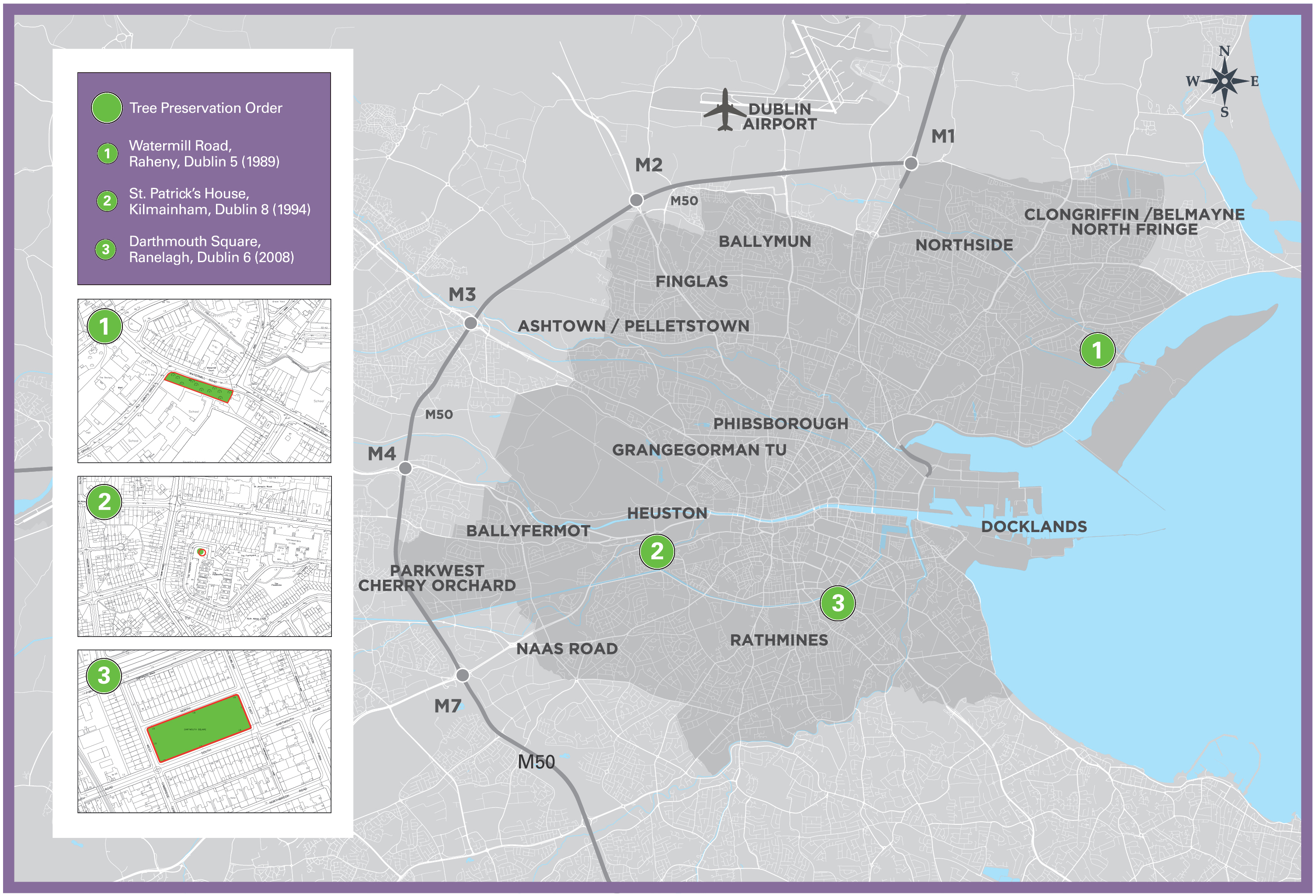
Figure 10-4: Existing Tree Preservation Orders (TPOs)
10.5.8 Sport, Recreation and Play
Increased physical activity helps improve the health and wellbeing of all people living and working in the City. For reasons of public health, a sustainable environment and social cohesion, the Healthy Ireland, A Framework for Improved Health and Wellbeing 2019 - 2025, the National Physical Activity Plan 2016 and Sport Ireland Participation Plan 2021 – 2024 set out objectives to increase physical activity levels across the whole population through formal sport and through enabling people to access parks and to walk and cycle to their daily destinations. Enabling opportunities for physical activity and active living is a priority of this Plan and a critical element in achieving healthy places.
Dublin City Council will continue to renew and develop sport and recreation facilities throughout the city and support their provision by community and private organisations. In this regard, the very important role that sporting and social clubs play in enhancing the social and recreation life of the city communities is acknowledged. Facilities and increased participation in sport for all people at all stages in their lifecycle and all abilities inclusive of girls/women and diverse cultures is required.
The Dublin City Council-led Sport and Wellbeing Partnership (DCSWP) will continue to work towards improving opportunities to enable Dublin’s citizens and workers to be physically active via targeted programmes and initiatives. The DCSWP is leading the Active Cities Project which sets out a goal for everyone in Dublin to have both the opportunity and motivation to actively participate in sport and physical activity with a vision that maintaining an active lifestyle could become an accepted part of the cultural norm in Dublin.
Playing is the most important aspect of a child’s daily life. Dublin City Council is committed to enabling local, accessible and inclusive opportunities to play for children and young people. The Draft Dublin City Play Strategy ‘Pollinating Play!’ 2020 – 2025 is underpinned by the United Nations Convention on the Rights of the Child (UNCRC) Article 31; the child’s right to play. It advocates for a child-friendly and playful city where all children and young people (ages 0-18) can enjoy and fully exercise their right to play and have child friendly physical activity. This would include access to playgrounds, youth focused spaces and opportunities for play friendly neighbourhoods and public realm.
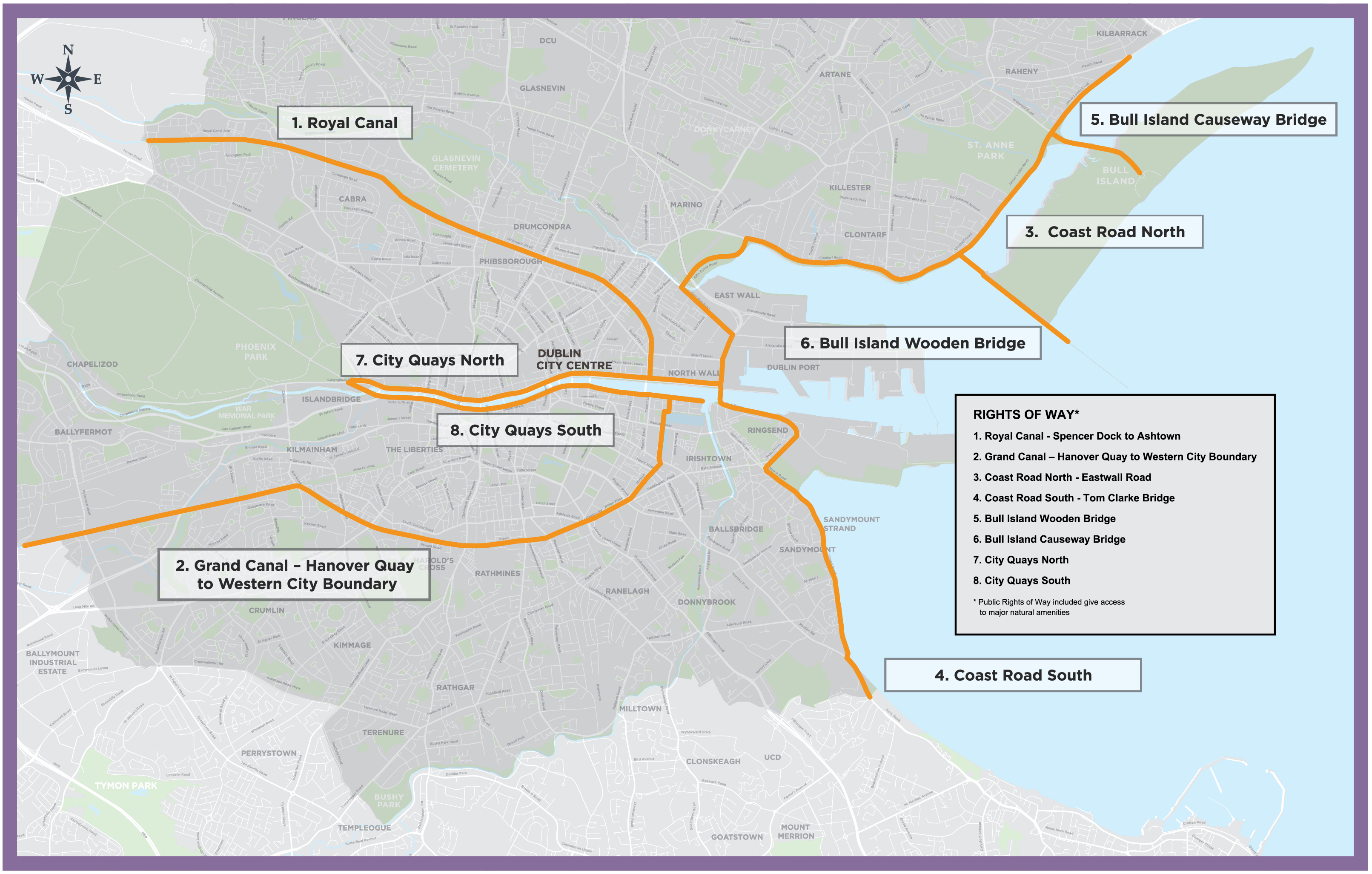
The city’s extensive permeable network of public streets, footpaths and cycleways provides people with access to the city’s major recreational amenities such as the coast, the city’s rivers and to the city’s numerous parks and open spaces. Figure 10-5 identifies and maps the strategic Public Rights of Way (PROW) in the city. Many of these PROW incorporate / will incorporate Metropolitan Greenways thereby promoting and enabling wider regional recreation and tourism objectives and also sustainable travel modes.
|
It is the Policy of Dublin City Council: |
|
|---|---|
|
GI45 |
National Physical Activity Plan 2016To improve the health and well-being of communities by increasing access to participation in sports, recreation and healthy activity in line with the National Physical Activity Plan 2016, the Healthy Ireland Framework 2019 – 2025 and the Sport Ireland Participation Plan 2021 – 2024. |
|
GI46 |
To Improve and Upgrade/ Provide Access to Sports / Recreational FacilitiesTo improve and upgrade existing sports/recreational facilities in the city and to ensure the availability of and equal access to a range of recreational facilities to the general population of all ages and groups (including women/girls and minority sports) at locations throughout the city, including housing complexes. In areas where a deficiency exists, Dublin City Council will work with the providers of such facilities, including schools, institutions and private operators, to ensure access to the local population. |
|
GI47 |
Private Recreational LandsTo support the development of private recreational lands for recreational purposes. |
|
GI48 |
Multiple Use of Sports and Recreational FacilitiesTo maximise the multiple use of sports and recreation facilities by encouraging the co-location of services between sports providers, schools, colleges and other community facilities. |
|
GI49 |
Protection of Existing and Established Sport and Recreational FacilitiesTo protect existing and established sport and recreation facilities, including pitches, unless there is clear evidence that there is no long term need for the facility; unless the loss would be replaced by equivalent or better provision in terms of quantity or quality in an accessible and suitable location; or the development is for alternative sports and recreational provision, or required to meet other open space deficiencies, the benefits of which would clearly outweigh the loss of the former or current use. |
|
GI50 |
Fenced Playing Pitches on Existing Open SpaceTo protect public open space and to generally restrict the development of fenced playing pitches on existing open space areas where it would exclude the use of the open space for other amenity related purposes when matches are not in progress. |
|
GI51 |
Children’s Playing Facilities - GeneralTo seek the provision of children’s playing facilities that encompasses local and public places and spaces for play that are accessible and inclusive for children and young people of all ages, abilities and socio-economic backgrounds. |
|
GI52 |
Children’s Playing Facilities in New Residential DevelopmentsTo seek the provision of children’s playing facilities in new residential developments. To provide playgrounds to an appropriate standard of amenity, safety, and accessibility and to create safe and accessible places for socialising and informal play. |
|
GI53 |
Public Rights of WayTo protect public rights of way as shown on Figure 10-5. |
|
It is an Objective of Dublin City Council: |
|
|---|---|
|
GIO43 |
National Public Health PolicyTo support the objectives of public health policy including Healthy Ireland Framework 2019 - 2025 and the National Physical Activity Plan 2016. |
|
GIO44 |
Active Cities ProjectTo support the work of the Dublin City Sports & Wellbeing Partnership and the Dublin Active Cities Project in creating, maintaining and increasing the numbers of people, of all ages, gender and ability, participating in sport and physical activity in the city. |
|
GIO45 |
Playing Fields StudyTo carry out a playing fields study to better measure the use and management (quality) of playing pitches and to examine the level of pitch provision required as a result of planned population growth, increased female participation in sport and the increase in demand for sports playing pitches. |
|
GIO46 |
Liaising with Sporting OrganisationsTo liaise and work with sporting organisations to ensure where possible, that the City Council responds to the needs of sports clubs and communities in the provision of quality facilities. |
|
GIO47 |
Multi Sports Hub in Conjunction with Fingal County CouncilTo investigate the potential for the provision of a multi sports hub in the outer suburbs to service the growing demand for pitch facilities in conjunction with Fingal County Council. |
|
GIO48 |
Dublin City Play Strategy ‘Pollinating Play’ 2020To support the implementation of the Draft Dublin City Play Strategy ‘Pollinating Play’ 2020 – 2025 which aims to provide inclusive and accessible play opportunities for children and young people and the integration of play provision and child friendly neighbourhoods. |
|
GIO49 |
Play Friendly CommunitiesTo support and encourage the development of play-friendly communities that provide time and space and permission for ‘everyday street play’, opportunities and experiences and play in urban public space. |
|
GIO50 |
STRIDE: 2017 – 2020To support the preparation and implementation of a new Dublin City Sport & Wellbeing Partnership Strategy. |
|
GIO51 |
Dalymount ParkTo redevelop Dalymount Park soccer stadium providing enhanced sporting, recreational and community amenities and as part of this development to celebrate the rich sporting history of this site. |
|
GIO52 |
Informal Recreational Space – Undeveloped LandTo examine the possibility of using suitable undeveloped land temporarily as informal recreational space. |
|
GIO53 |
Water Sports and Leisure Activities To support the development of a public lido and other facilities to provide water sports and leisure activities in the City Centre. |
|
GIO54 |
Olympic Standard Velodrome To support the development of an Olympic standard velodrome in the city region. |
|
GIO55 |
Marrowbone Lane Depot To develop the council owned depot at Marrowbone Lane as a Green Infrastructure and Recreational Area. |
|
GIO56 |
Public Rights of Way To identify further significant public rights of way during the lifetime of the development plan and to update the ‘Public Rights of Way’ map. |
Figure 10-5: Public Rights of Way
[1] Ireland's Environment – An Integrated Assessment 2020. EPA (2020)
[2] DCHG (2019) Ireland’s 6th National Report to the Convention on Biological Diversity. Department of Culture, Heritage and the Gaeltacht. https://www.cbd.int/doc/nr/nr-06/ie-nr-06-en.pdf
[3] Dept. of Culture, Heritage and the Gaeltacht (2017) National Biodiversity Action Plan (2017-2021).
[4] Ecosystem Services are the direct and indirect contributions of ecosystems to human wellbeing. There are four main types: provisioning, regulating, supporting and cultural services, see Table 10.1.
[5] Benedict, Mark A., and Edward T. McMahon. Green infrastructure: linking landscapes and communities. Island Press, 2006.
[6] Community Parks Grade 1 serve local communities, have a good range of amenities and have a high standard of design or horticultural presentation and are approximately 10 ha in size. Community Parks Grade 2 serve local communities and have a range of amenities or are primarily used for active recreation and are approximately 5 ha in size.
Clár ábhair
Observations
Observations
10: Green Infrastructure and Recreation
10.5.1 Policies and Objectives – Green Infrastructure
Policy GI3 Multi-functionality (pg. 358...